May 24, 2011

5/24/11 – Fort Frederica NM

We drove up to Fort Frederica National Monument on St. Simons Island in Georgia.  We’re staying north of Jacksonville, FL, but it was easier to drive there from here than move house for a single day. 
They had a movie in the Visitors Center about the history of the fort.  We missed the beginning of it when we first got there, so went outside for the tour first--after I played colonial dress-up! 
Fort Caroline was French; Castillo de San Marco was Spanish.  Fort Frederica was a British fort and town.  (It’s been a very international week!)  It was built in the 1740s on St. Simons Island, GA, by General James Oglethorpe.  It was the southernmost post of the British colonies, like Castillo de San Marco was the most northern post for Spain.   The fort was built on the Frederica River to protect Georgia colonies.  The town was planned in a grid by Oglethorpe and built by the “worthy poor” he transported from England.   It had wide streets and each settler was given a big lot; the homes were built of wood, brick or “tabby”, which is sort of like concrete made of oyster shells, sand and lime.  Apparently it was quite a nice little town. 

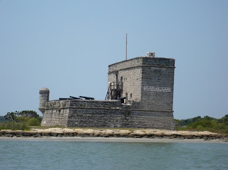
Remains of Fort Frederica

All that's left of the barracks is 3 walls on the tower
Oglethorpe’s troops defeated the Spanish in the Battle of Blood Marsh in 1742, during the “War of Jenkins Ear”, ensuring Georgia's future as a British colony.  The ranger said that Jenkins was a sea captain, captured by the Spanish who cut his ear off.  He took his ear to Parliament in London, and they declared war on Spain.  Wow!  This even beats the"Pig War" in the San Juans. 

Eventually the fort and town pretty much disappeared, with only remnants of the tower to the soldiers’ barracks remaining.  In 1947 archeologists came in and started sifting through the dirt.  They found foundations of several of the houses, and were able then to lay out the streets and lots in the town.  The foundations are still there, filled with oyster shells to protect the site.  You walk through the town, nestled under big live oak trees and Spanish moss.  There are lots of descriptive signs, so with very little imagination you can visualize the way it was. 
When we came back inside, our timing was still lousy—next showing was going to be in 25 minutes.  We got lunch out of the truck and sat at a picnic table to eat first.  We sprayed with Deet when we got there, but I still got bites. 
While I go scratch, you can check out the pictures of Fort Frederica:   Fort Frederica NM 

May 23, 2011

5/23/11 – Castillo de San Marcos NM

Castillo de San Marcos National Monument is the oldest masonry fort and best-preserved Spanish colonial fort in the continental US.  It’s right across from historic St. Augustine on Matanzas Bay.   I knew about St. Augustine, but nothing about the fort.  We stopped at the St. Augustine lighthouse on the way.  Saw the film about its history, but opted not to climb all the way up into the lighthouse itself.

No free parking at this park; we had to feed a parking meter which only takes quarters—and ours get saved for laundry.  George had to ask someone to change a dollar for us, and then we could head to the Castillo.  
We listened to a history talk by a ranger, then wandered around with a “Self-Guided Walking Tour” I’d picked up.  This must be field trip season, because it was full of elementary school kids and their chaperones.  We really did try to stay out of their way.

The Castillo was finished in 1695—there had been 9 other wooden forts in the same location, but this one was built of blocks of stone.  It protected St. Augustine from pirate raids and from those pesky British.  During the War of Spanish Succession in 1702 (not in not my American history book!) the English occupied St. Augustine and lay siege to the Castillo for 50 days, with 1,500 soldiers and townspeople inside.  The fort was again attacked in 1740, but those walls made of coquille shellstone just absorbed cannonballs.  The moat outside the Castillo wasn’t filled with water, but was used as a corral for livestock during attack.  The way the moat and outer walls were built, you could only see the top 1/3 of the castle.

It’s a really odd shape, a hollow square with diamond-shaped bastions sticking out at each corner. That way there were no blind spots and every approach to the fort comes into a cross-fire.  They had LOTS of cannon. 
Six different flags flew over the fort:  two different Spanish flags, British, the Confederacy and the United States (twice)—but it never lost a battle.  It was always transferred by treaty, not war.   

We looked around historical St. Augustine for a bit, but the meter was running out so we didn't stay long.  
St. Augustine Lighthouse

5/23/11 – Fort Matanzas NM

Fort Matanzas National Monument is on Anastasia Island and the only way you can visit it by taking an NPS ferry.  When we got to the Visitors Center, there was a sign out front “Ferry out of service today”.  (NO!  We’d driven quite a ways to only see the fort across the river.)
We went inside so George could at least stamp his passport.  The ranger said the Coast Guard had just called and cleared the boat for service!  (Yahoo!)  We chatted for awhile then headed down to the dock.  Once we had loaded, a ranger gave us a little history talk about the fort which guarded the “back door” to St. Augustine. 
Fort Matanzas (“slaughter” in Spanish) marks the site where almost 250 French Huguenot soldiers from French Fort Caroline were killed by the Spaniards in 1765.  The fort was built in 1740-42 to prevent the British from attacking St. Augustine. 
Once we crossed Matanzas Inlet to the fort, we were free to wander anywhere we wanted inside the fort.  The fort had been a real mess by the 1900's, and there was some repair done in 1924.  Actual rebut was restoration was done by the WPA in 1937.  Built of a local shellstone called coquina--which another ranger described later as “fossilized beach”--it's really blocks made of shells, sand and lime.  They've set up an exhibit in the Officer’s Quarters and Soldiers’ Quarters set up so you can see how they would have lived.  We climbed up a ladder through the roof onto the Observation Deck. 
The guns were used to hold off British attempts to gain the inlet in 1742, and that was the only battle it was ever in.
 After we’d all seen everything, they took us all back across on the ferry.  We picnicked under a big live oak tree before we headed to St. Augustine. 

May 22, 2011

5/22/11 – Fort Caroline NM & Timucuan E&HP

Most of the parks we’ve visited have been unique natural resources and we went there to look at the landscape.  Now we’re getting into areas where battles have been fought, people or places are being honored or remembered, and we’re there to learn about history.  My US history classes were a long time ago, and most of it forgotten.  Oh, well…maybe we can all learn together.
Timucuan Ecological & Historic Preserve is just east  of Jacksonville, FL, where the Nassau and St. Johns rivers flow into the Atlantic.  There are actually 4 different areas to the preserve:  Fort Caroline National Memorial, Theodore Roosevelt Area, Kingsley Plantation and Cedar Point. 
My Guide to America’s National Parks lists Fort Caroline NM and Timucuan E&HP as two separate places to go…but when we got to Timucuan, Fort Charlotte is right there on the grounds.  Theodore Roosevelt Area preserves a hardwood hammock and evidence of the Timucuan Indians, who were there when the French came.  It was a 3 mile hike and it was hot (93) and humid (sweaty).  Cedar Point is undeveloped.  The Kingsley Plantation has the oldest remaining plantation house in Florida—but the main house is closed for repairs and you can’t go inside the other buildings unless you’re on a ranger-led tour for which you need reservations.  Okay--Fort Caroline will do.
The ranger at Timucuan suggested that because it was so hot we walk down to the reconstructed fort first, then come back and view the exhibits in the Visitors Center.  That worked for us.
Fort Caroline was built by the French in 1564.  It’s right on the St. Johns River and built with just 3 sides, one towards the river, and the other two to protect the little colony of Huguenots.   The next year the Spanish marched in and massacred most of its defenders.  The French later sailed in and burned the fort, but the Spanish maintained control of Florida for the next 200 years.  (That’s our American history lesson for today.)

We checked out the fort—which I later learned is (a) not an exact replica because no one really knows what it looked like and (b) is only 1/3 the size of the original fort.  It’s has a triangular shape, with funny pointy corners.  I learned the pointy corners are called “bastions”, and common in fortifications of the time.
After we finished there, we went back to the Visitors Center.  Then we went grocery shopping, and home*. 

A few more pictures:  Fort Caroline NM

*Home is where you park it.

May 19, 2011

5/19/11 – Kennedy Space Center

The shuttle launch was Monday; we visited the Space Center on Thursday.  It’s not a national park, but it’s on NASA property, so I guess that counts.
Lovebugs are still out in full force on the Space Coast of Florida, so standing in line for tickets was miserable with them flying all around.  (And no, I don’t know why the Floridians nickname sections of their coast.  Besides this one, there’s the Gold Coast and the Treasure Coast; there’s a Sun Coast, Nature Coast and Emerald Coast; also the First Coast and the Forgotten Coast! I’m not sure what’s wrong with just the Atlantic and Gulf coasts…it’s not like any other state has more than one anyway.) 

We spent most of the day there and still didn’t get to see it all.  It’s a lot like Disneyland with only Tomorrowland--there are rides and movies and lots of historical exhibits.  There's a place called the "Rocket Garden" which has a bunch of the actual rockets and capsules that were used. We went to the Astronaut Memorial, walked through one of the shuttles (Explorer, I think), saw lots of old space and astronaut stuff, the real Mercury mission control consoles, along with a pretty neat video about the Apollo launch), took a bus tour out to the Observation Gantry for the space shuttle launches where you are practically next to the crawlerway to move the shuttle out to the launch site.

The bus also went to the Apollo/Saturn V Center which has one of the moon rockets inside! We saw a 3-D Imax film about when they did some repairs on the Hubble, plus some amazing pictures that it took. (We were too close to the screen and had to look up for the movie, but we barely got back from the bus tour in time to get in.) There were still other things we didn't get a chance to see, but it was a full day. Amazing how much of this stuff I actually lived through and remembered--and how much I lived through and didn't remember...     
Vultures behind the Apollo Saturn V Center
LC39 Observation Gantry
Went to a local restaurant on the way back. We both had rock shrimp, which don't taste like shrimp. No, they don't taste like chicken--they taste like lobster! Shells aren't peelable unless they're split down the back and then broiled. Even then, the shells are really hard. Yummy though.
George’s SD card broke and none of his pictures were transferrable.  Bummer!  I gave him all mine, but he always takes more and of different things than I do.
Link to Kennedy Space Center pics 

May 18, 2011

5/18/11 – Canaveral NS

It’s almost 50 miles from Merritt Island NWR to the Visitors Center at Canaveral National Seashore--as the crow (or heron) flies, it's about half that, but you have to go around.  They’re either building or remodeling the bufilding, so they had everything temporarily housed in a trailer.  We chatted for quite a while with the volunteer there, and then he suggested that we go to Eldora House, even though we wouldn’t be able to see inside. 
It’s about all that remains of the town of Eldora, but the restored home is lovely. 

We were standing near it reading a sign when we heard a great big splash in the water behind us.  George saw dolphin fins, so we went out on the fishing dock to watch.  There were at least 6 of them, apparently feeding.  Mostly what we saw was when they came up to take a breath.  We’d hear the blow, then watch them as they rolled back down for a dive.  One had a dorsal fin that was pretty chewed up.  One always had a smaller fin next to it, so we thought it was probably mom and baby.  One stayed really close to shore and seemed to be practicing that routine they do when they swim around in a circle to herd the fish, then pop up from underneath.  George got a picture of that one coming out of the water.  I’ve got lots of pictures of dorsal fins… 
 After watching them for about 20 minutes, we headed back to the truck and down to the end of the road.  We took pictures of the beach, then headed back to the Manatee overlook at the Haulover Canal.  Didn’t see any manatees, but it was great fun watching the dolphins!

5/18/11 - Merritt Island NWR

We didn’t even realize there was a National Wildlife Refuge nearby until George saw a sign on the way to the RV park.  We’d only driven 60 miles that morning so after we had lunch, we headed to the Visitors Center.
Merritt Island NWR shares a common boundary with NASA’s Kennedy Space Center (think Cape Canaveral).  The long barrier island is on the Atlantic Flyway, so there are lots of birds!
The volunteer at the Visitor Center sent us out onto the short boardwalk out back (we saw a screech owl in a tree hole, but it was too shady to get a decent picture).  Then we went down the road a piece (maybe I’ve been in the south too long—that just popped out!) to Peacocks Pocket road out along the dike.  It’s not very long, but it’s super-narrow and twisty but there’s a lot to see.  
On one side is the Indian River Lagoon and on the other through a marsh with lots of little hammocks.  We saw several kinds of herons and egrets, stilts, ibis, osprey, red-winged blackbirds, plus lots more. 

Since we’d started so late in the day, we decided to forego the other driving and hiking trails the lady had suggested, and headed north up Hwy 1, then south on A1A to Canaveral National Seashore*.

On the way back, we stopped at the Manatee Observation Deck by the Haulover Canal.  (Trick question:  Did we see any manatees?  Answer:  Of course not!!!—but the folks that were just leaving had seen two while they were there!)
*There's a separate blog post for Canaveral NS. 

May 14, 2011

5/14/11 – Key Largo & John Pennekamp SP

Since we were in Homestead, we definitely wanted to go to the Keys.  George talked about Key West, but that’s a long way, and I didn’t care if we went that far south or not.
There’s a state park in Key Largo called John Pennekamp Coral Reef State Park.  It was the first undersea park in the US; you can go out to the reef to scuba dive or snorkel.  My SCUBA license is at home, and probably needs to be updated anyway since I haven't dived in 25 years.  George isn’t interested in snorkeling, so we opted for the glass-bottom boat tour.  I made reservations for the noon tour since I knew I couldn’t get George there by 9:30, even though it was only 20 miles from where we were staying.  This sign was at the SCUBA gear kiosk—cracked me up!
There was a huge bike race or something going on that day, and traffic was absolutely ghastly!  One of the end-points was in the park and the entrance was closed to all but bicycles.  We drove past, called the park to find out how to get in, and then came back to tell the cop on the corner that we had reservations for a tour. 
While we were waiting, we went to the Visitor Center where there’s a big saltwater aquarium.  We had lunch before we went on the boat, so—except for the Dramamine—we were all ready.  
It takes about 45 minutes to get out to the reef.  We saw lots of beautiful fish and lots of different kinds of coral.  Most of the pictures didn’t work for me, but I tried…at least for a while, then just sat back and watched the fish.
Afterwards we drove down into Key Largo and took pictures of the original African Queen boat from the Bogart/Hepburn movie.  Kinda cool.
We were both tired after the sun and wind (and Dramamine) so when George suggested we head back, I was OK with that. 
Here are a few more pictures we took:  Key Largo & John Pennekamp SP

May 13, 2011

5/13/11 – Biscayne NP

Biscayne National Park is really close to where we were staying in Homestead.  We didn’t even bother to pack a lunch! 
There wasn’t a lot to do at Biscayne because 95% of the park is water, protecting islands fringed with mangrove forests and coral reefs.  Without a boat, we had limited options, and the 5th wheel doesn't float.  We went to the Dante Fascell Visitors Center, watched the park movie and walked out a short trail that goes out to a pier. 
We did meet some nice folks from Oklahoma who had just returned from a cruise to the Bahamas, so we chatted and walked with them and tried to spot the fish.  Please note:  no fishing in trees! 
There aren't many pictures because we didn't go out to the reef.  Biscayne NP

May 12, 2011

5/12/11 – Everglades NP (south)

There’s more to Everglades National Park than the north side that we visited from Big Cypress, so we headed to an RV park in Homestead.  From there it was about 10 miles to the park.  We drove through fields of tomatoes and papayas (well, not growing together…), but it is certainly amazing the number of produce stands there are around Homestead. 
Ernest F. Coe Visitor Center was our first stop.  We talked to the volunteers and toured the exhibits before we went out on the boardwalk around the “Borrow Pit” behind the building.  The doors to the gift shop are beautiful! 
Next stop was Royal Palm where there were two trails.  Anhinga Trail goes around Taylor Slough where we saw birds and alligators.  There was an Anhinga perched on the boardwalk railing, and had no hesitation about people being near, and sometimes she’d open her wings to show off. (I have lots more pictures of this bird, if you’re interested.)  There were lots of Anhinga, even more Black Vultures--which might as well be the Florida state bird, there are so many of them!  And there were alligators.  (If you haven’t figured it out by now, any puddle of water in Florida probably hosts at least one gator.  They’re beginning to lose their enchantment as far as I’m concerned.)
Then we went on the Gumbo Limbo Trail through a hardwood hammock.  I’d go on that trail just because I like to say “Gumbo Limbo”.  There were gumbo limbo and mahogany trees, as well as the ubiquitous palms.  We saw lizards and I finally saw the ever-elusive tree snail!
We decided to head straight to Flamingo Visitor Center on Florida Bay, and hit the other trails and overlooks on the way back.  It was still really smoky from the Big Cypress fire.  I know the wet season hasn’t started yet, but I was really surprised that the Everglades were so dry.  And so grassy.  I think I expected the Okefenokee Swamp…
The Flamingo Visitor Center is (surprise!) pink—but there are no flamingos there.  There’s a big boat marina.   We wandered around looking for manatees (couldn’t find any) and American Crocodiles.  One of the guys who worked at the marina pointed out a crocodile under the shade of some trees on the riverbank across from us.  I’ve got a not-very-good picture, but you have to trust me a little bit.
The wind was picking up and the sky was getting darker, so we decided to head for the truck.  By the time we got across the parking lot, the rain was splatting and the lightning was rolling.  Good thing George was driving because I would have pulled over and waited for the storm to pass; he just drove a little slower.  
Typical Florida thunderstorm passed in less than 10 minutes, but we could see others on the way.  We decided not to try any hikes, just quick stops on the way back.  We stopped at Paurotis Pond to see the wood stork rookery.  There were wood storks, roseate spoonbills, egrets, herons…Wow!  You could see them better with binoculars than the cameras, but I tried.  You wouldn’t believe how noisy they were!
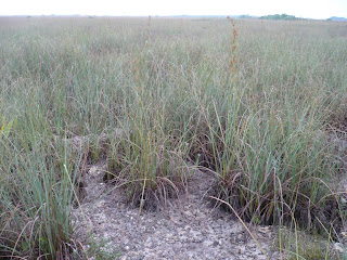
More lightning all around us, and I wanted to stop at the Pa-hay-okee Overlook to see the River of Grass.  We waited until there was a lull between black clouds and rushed across the boardwalk to the observation tower.  There was lots of sawgrass, but the ground was dry down to dusty limestone. 
On the way back home*, we stopped at a big produce stand called “Robert Is Here”.  I got a key lime milkshake and George got strawberry-passion fruit.  Yum!
More pics:  Everglades (south) 

*Home is where you park it.