
I'm not sure what I expected at
Big Bend National Park, but the reality was
way better than whatever my unrealized expectations were.
Before we arrived, people had told me how beautiful it is--but one lady
told me, "It's a whole lot of nothing!" Yes...it is in the Chihuahuan Desert, but there's a lot more than boring desert to see there. That lady missed a lot of good stuff.
Big Bend is the only park in the US
that has a whole mountain range inside its borders. The Chisos
Mountains are cleverly situated in the center, so wherever you are, you can
see their craggy silhouettes. I like the purple-mountain-majesty layers with shadows rather like
the Blue Ridge Mountains, only without the obnoxious overgrown trees that block the
view. (There aren't a lot of trees in the desert.)
There are three different ecosystems in Big Bend: river, desert, mountains. One segues into another, transitioning with each mile traveled. Views are different as the clock ticks, terrain changes if you
blink, plants vary from cactus in the desert to oaks and pines in higher elevations. On the other hand, it’s a big park and everything is a long
way from everything else. We were in the
park five days and drove almost 400 miles inside the park! Good thing it was worth it--diesel's pretty expensive around there.
Day 1: The river, of course, is the Rio Grande, the border between the US and Mexico. It wanders 118 miles along the southern and eastern
border of the park—including the 90-degree
big bend that the park’s named for--through narrow canyons and meandering across the desert. I think I've seen too many westerns, because
it wasn't quite what I expected. Well, maybe parts of it were:
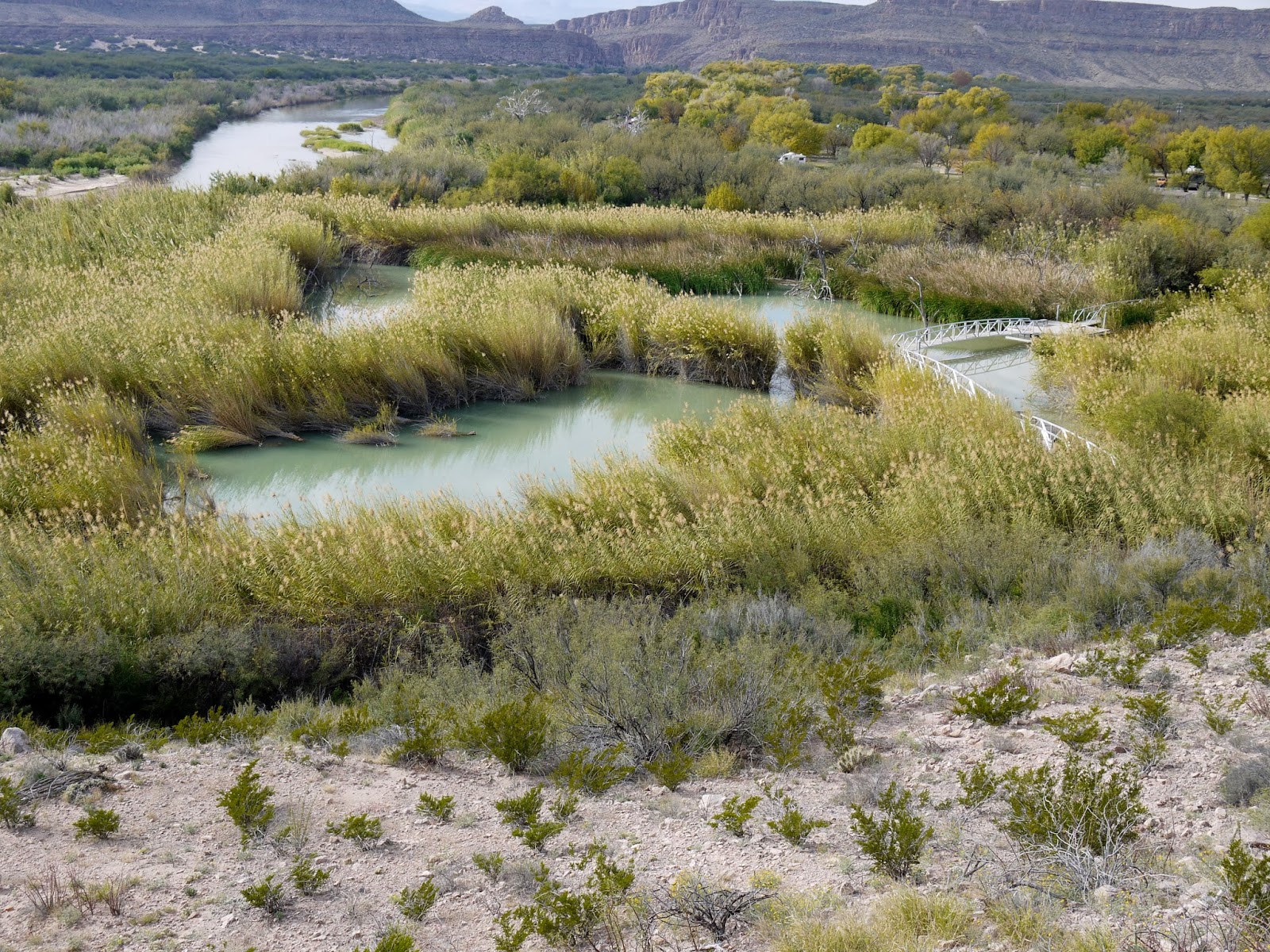
We walked the Rio Grande Village Nature Trail from a campground to a
wildlife viewing platform on a pond, with big tall marsh grass, then up a hill
with a view of the river. Never saw that
in a John Wayne movie!
There were little
piles of walking sticks and beaded souvenirs all over, with jars for your money. There are also signs from the park
service saying that they’re contraband and will be confiscated. The rangers are pretty sympathetic to the
people in the little town across the river. The Border Patrol isn't.
The border’s been closed until very recently, and the poor (both
definitions of the word) people are just trying to make a living.
We drove a little further to hike to Boquillas Canyon, climbed a little hill, then down to the
river again to see where the water flows into the canyon. On the way down the hill, we met a Mexican guy on a horse on his way to collect the money tourists left. He seemed pretty nice, but we didn’t buy any
of his arrowheads. George did talk to his horse.
I dipped my hands in the water.
I think you’re supposed to wade it, but I didn’t want to take off my
boots...
The range called Sierra del Carmen is in Mexico. I like the stripes, especially when the sun shines just on the mountains.
 Mountains were on the agenda the second day. I went out before George got up and took
pictures of the changing clouds and colors over the Chisos as the sun came up. (It’s December and not much of an effort to
see a sunrise at 7:30.)
Mountains were on the agenda the second day. I went out before George got up and took
pictures of the changing clouds and colors over the Chisos as the sun came up. (It’s December and not much of an effort to
see a sunrise at 7:30.)
The road up to Chinos Basin climbed 2,000 feet from the desert below. We walked the short Window View trail from
the Basin Store for a view of The Window.
Then we hiked the Basin Loop Trail that sort of linked sections of high country
trails. There were definitely trees, sorta scrubby, but real trees. Oh,yeah, and bears and mountain lions too...so they say.
Day 3: We opted to drive the Ross Maxwell Scenic Drive by driving the loop
backwards from the western entrance of the park on the gravel Old Maverick Road. *Not sure if it was named after Bret's and Bart's Pappy or some old cow.) The less-than-wonderful road winds across the desert to the Rio Grande where the river comes out of the Santa Elena Canyon.
We walked up the steps to the canyon overlook, then walked a short way into the canyon until we ran out of path. The cliffs rise 1,500 feet above the water.
We drove on to Castolon and checked out the little Visitor Center
there, then headed north on the east side of the loop. This nearby butte is called Cerro Castellan, which might mean something like
Governor's Castle--but it's been a while and I forgot. Anyway, I thought it was pretty cool.
I really liked the drive through Tuff Canyon. I’d like to hike down into it some time.
This is the view from Mule Ears View Point.
I’m not sure that’s the best name for those peaks, but I doubt if the park
service would accept other suggestions since this is on all the maps.
Day 4: I have no idea how many times we drove past the turnoff to Grapevine Hills this week,
but this time we drove the 8 miles on the gravel road to hike out to Balanced
Rock. We saw a tarantula. Okay, I really, really, really don't like spiders. I didn't have a problem with this guy. I think it's because he doesn't look like a real spider--I think he looks like a kindergarten project made of pipe cleaners.
The trail heads out across the desert towards the ridge.
Then there's a bit of a scramble to the balanced rock.
We were staying at a campground in Terlingua just outside the park—just
hookups in the desert, but the sunsets were magnificent!
Took lots of pictures here; click on the link to see more:
Big Bend NP

 I checked the map and saw that Coronado NM wasn't too far away from Bisbee. When I told George it had a Visitor Center, he was up for it. One more park stamp in his passport book. Neither of us had a clue what was there or what to expect. Usually I research where we're going, but definitely fell down on the job this time.


.JPG)
.JPG)

.JPG)


.JPG)
.JPG)
.JPG)


.JPG)
.JPG)
.JPG)
.JPG)
.JPG)
.JPG)

.JPG)


.JPG)


.JPG)

.jpg)
.JPG)
.JPG)
.JPG)

.JPG)


.JPG)