September 30, 2016

9/23/16 - John Day Fossil Beds NM, Painted Hills Unit

Painted Hills is the 3rd unit of John Day Fossil Beds National Monument.  We went to the Clarno Unit in 2010, and the Sheep Rock Unit a couple days ago. Today we headed west on US 26, The Journey Through Time Scenic Byway.  George wasn’t happy about backtracking 50 miles, but he wouldn't have been interested in dragging the trailer through here.  Since I’d blown that suggestion at the Clarno Unit, I just kept my mouth shut.

The Painted Hills are one of the “Seven Wonders of Oregon”. (The others are Crater Lake, Smith Rock, Wallowas, Mount Hood, Columbia River Gorge and the Oregon Coast.  We’ve been to Crater Lake, the Gorge and the Coast--maybe someday I’ll work the rest in.)  The entrance is a little understated.  Many of the hills along Bridge Creek are just that...ordinary hills. 

Along Burnt Ranch Road, the hills started to show signs of color.
There’s no visitor center (the one at Sheep Rock serves all three units, probably because Clarno and Painted Hills aren’t as accessible and don’t get as many visitors.)  There’s a little picnic area with an office or something for the ranger, but it was closed when we got there.  I already had maps of the trails.  All roads in the park are gravel, but in decent condition.  The colors change in the light, with shades of red and yellow contrasting with browns and tans on the hills.  You look, take a picture, point the camera somewhere else, look back and zoom—and it’s different.  Sometimes the colors almost bleed.  

Up close, this:
Becomes this:
                                         
We skipped the steep climb up the Carroll Rim Trail, and chose the shorter Painted Hills Overlook Trail on the other side of the road.  Since we’re both 70 now (or very close to it!), we’re opting for the shorter hikes instead of the longer ones.  Actually, we never did go on the really long ones...
                               
Next up was Painted Cove, where the trail winds around a little hill, part of it on a boardwalk so the soil isn’t disturbed.   Depending on the light and the angle, the colors change as you move. The reds are from iron oxide (think rust!) and range from brick to merlot. The yellows and oranges are a blend of iron and magnesium oxides, and vary from ochre to Dijon.  If you’re in the right mood, you can identify lavenders from rhyolitic lava.  (Yes, I copied the mineral stuff from a sign.  Most of you would too!)  

                                         
Even the lichen on the rocks comes in cool colors:
                                    
The hill is made of claystone, which looks like dried cracked mud.  One of the info signs says the hill is 33 million years old.  Seriously?  The hillsides erode after big thunderstorms, leaving miniature canyons where the slurries of clay run off, draining off bits of the hill every time it rains.  I cannot believe that a hill so delicate could have possibly lasted 33 million years!  You’re not supposed to walk on the hills because they cause even more erosion.   They certainly leave ugly trails.  If the hills are 33 million years old, then the original size must have been mind-boggling.

                                    
You can see the boardwalk around the hillside here.  I like the way that sometimes the colors are aloof and distinct, and sometimes are friendly and mingle.

Next up was Leaf Hill Trail, a loop around a Leaf Hill where lots of fossils of leaves from hardwood forests were found.  They were pressed like flowers in the ashy lake sediments, and later turned to shale.  The hill is unprepossessing, even off-putting, reminding me of a pile of broken oyster shells.  The trail goes around the unappealing mound next to me, not the colorful stuff in the background. (The last picture is a closeup of the pieces of broken shale on the hill.)
                                

The last trail seems to have an identify crisis, variously called Red Scar Knoll Trail and Red Hill Trail.  (I’ll go with the more descriptive name rather than the plain one.) The white on the hill behind the parking lot is from volcanic ash, which of course, you already knew...
                                             
The hill is definitely RED! And the other's really yellow!

Which unit of John Day Fossil Beds do I like best?  This one.  I tend to go for the splashy “Wow!” in nature.  And these painted hills have a lot of that.

Here's the link to more pictures on Flickr:  John Day - Painted Hills 

And here are links to the other two Blog posts:
           John Day - Clarno Unit   
           John Day - Sheep Rock Uni


September 28, 2016

9/21/16 - John Day Fossil Beds NM, Sheep Rock Unit

We’d gone to the John Day Fossil Beds National Monument at the very beginning of our trip in 2010, but that was the Clarno Unit. (See John Day Fossil Bed - Clarno Unit). The park has 3 units, 20 square miles in 3 separate locations.  Seems pretty chintzy after the ranger showed us the map of the 20,000 square miles of the region in Oregon they call the “John Day Fossil Beds”. 


The Sheep Rock Unit is the closest unit to a town (Dayville, OR, population 148) and the only unit with a Visitor Center.
·          
The Visitor Center is across from Sheep Rock.  Seems like it would have to be a pretty brave sheep to climb up there and view his domain.  We didn’t see him.
Obviously a park named for fossil beds has fossils.  (However, you’re not allowed to look for them, disturb them, or even pick them up! It's a rule.) The museum has a pretty good exhibit with lot of fossils from various layers of strata.  This isn’t a dinosaur park, and the fossils are mostly mammals.  Pretty big and pretty weird mammals, and they have non-pronounceable scientific names.  They do occasionally say this one’s a sheep, that’s a dog, over there’s a hippo-like rhino (or maybe they said it was a rhino-like hippo?) I actually thought the sheep was a hippo, and the horse looks like the sheep.  The sabre-tooth tiger sort of looks like I’d expected, so I’d at least know to run from the right critter.
We stopped at the Goose Rock viewpoint, and I took some pictures, but I never did figure out which one is Goose Rock. I didn’t see a rock that looks like a goose, but I didn’t see a goose on a rock either.
Blue Basin - There’s a loop trail around Blue Basin where you climb to an overlook of the badlands, but it's marked as strenuous because of the elevation gain.  I figured if we did that one, it would be the only one George would want to hike that day, so I opted for the shorter Island in Time Trail -- a round trip of a whole 1.3 miles along the canyon floor, with 13 open steel mesh bridges crossing the creek bed.  (They tell you not to take your dog because you'll have to carry it across. Probably okay with a Papillon, but not a Bernese Mountain Dog.) I tried counting the bridges, but I'm not sure I got it right.
 
Not quite sure why they call it Blue Basin—the colorful layers of claystone are green, not blue.  I did an informal survey and asked several people (well, George and one other guy) what color they’d call the rock if they were naming it.  They both said, “Green”.  With my vote, that’s unanimous!  But the green’s not copper, like you'd expect--it’s celadonite.  (I didn’t know that either, but there was a helpful ranger at the info center who explained all that to us.) There are scads of layers of old volcanic ash, some hard, some soft, topped off with a covering of basalt.  This stuff is all crumbly, and there’s evidence of rockfall all over. Keep in mind we’re at the bottom of the cliffs, and gravity only works one direction. If you're nervous, don't look up.
Foree Area – Nope, don’t know why they call it that.  I'm guessing it was the name of the guy who owned the property before it got transferred to the park service.  (If there’s no interpretive sign, I always use my imagination.)
There are two trails here, but only one wooden bridge, so feel free to bring your dog.  We started with the Story in Stone Trail. It’s a little loop of  1/3 mile, where you can see several badland outcroppings that have been exposed by erosion. 
The Flood of Fire Trail is even shorter, out and back isn’t even ¼ mile, no bridges, but a few steps.  It ends at a cliff face with dark red rocks on top, and a view down to the river valley.  See if you can see the windsock for the landing strip across the road.
We stopped at Cathedral Rock on the way back, but the sun wasn’t in the right position so there’s a big glare. 
More pictures?  Go here:  John Day Fossil Beds - Sheep Rock  

September 23, 2016

9/16/16 - Dee Wright Observatory

Larry and Carolyn took us to Dee Wright Observatory at another Oregon lava flow—this one at the summit of McKenzie Pass on Highway 242.  Dee Wright, a forest service worker who as a CCC foreman started installation of a viewfinder among the lava fields.  He died before the project was completed so they named the observatory after him. (Wonder what they called it before?  Wonder if he actually cared?)
                     
Built of black lava rock atop a ridge of lava, it’s camouflaged as the remnant of an old volcano dome, with just the plug showing.  The windows could be vent holes.  Or not...
A group of people coming down the steps looked familiar. Turned out the four of us knew the four of them!  Two couples we’d met in Arizona one winter live in Bend and were out for a drive with other RV friends.  It always amazes me that as big as this country is we can still meet people we’ve met somewhere else.  Wonder what the odds of that actually happening is?  I think we should keep traveling and see who else we’ll meet. I'll call it "Random RV Encounters".

After all the greetings (and more pictures), they continued on their excursion and we headed upstairs to the observatory.  Inside, each window is a viewfinder to specifically identify individual mountain peaks. Under the window is a concrete plaque with the name of a peak--which you could sometimes still read.  The windows are aimed at individual mountains in the distance.  On a clear day you can see all the way to Mt. Hood, about 80 miles away.  The sky was blue and beautiful, but it apparently wasn’t good enough for Hood to put in an appearance.  Actually I thought I could almost see it through the haze, but that might have been my over-active imagination.  Maybe not....my imagination tends to create bears instead of mountains.
Back outside, and up a few more steps is a big bronze compass with the names of all the peaks on it. That’s two of the Three Sisters (and Little Brother) over 5 miles away. "Sister" seems to be a very popular name for mountains in the US.  
The Lava River National Recreational Trail is a simple half-mile loop.  Simple because it’s paved and you don’t have to clomp your way rock by rock through the lava field.  Personally I would have preferred the clomping, but nobody else would have.  
There are interpretive signs along the trail, pointing out interesting features.  One of the first was a wagon route across the lava!  Why would anyone think that it would be a good idea to haul a wagon across this stuff?  I admit their trail looks a little flatter and smoother than the adjoining lava field, but this seems downright stupid!  I can imagine crossing the flat, hot, boring plains to get to Oregon.  I can imagine crossing the Rockies.  But a huge lava field?  Absolutely NO WAY!

There’s one area with a big wall of lava towering over the trail. 
The lava field isn't completely barren--there are plants growing in some of it.  Tenacious, determined, stubborn ones, but trees do grow here.  (I think that thin in the foreground looks like it should be somewhere tropical.)
Interesting walk through a tiny portion of the 65 square miles of lava field protected by the forest service.  We chose not to continue the rest of the McKenzie Pass-Santiam Pass Scenic Byway loop and headed back to Sisters for lunch.  That would be the town of Sisters, not the mountains. 

More pictures here:  Dee Wright Observatory

September 22, 2016

9/15/16 - Newberry NVM

We hooked up with friends at a campground near Sunriver, Oregon, and went with Carolyn and Larry to visit Newberry National Volcanic Monument.  This park isn’t part of the National Park Service, but is overseen by the U.S. Forest Service.

The FS and BLM sometimes get the short end of the stick when it comes to national monuments, but this time the FS got lucky.  This is a pretty cool place to visit, even if it doesn't get all the publicity the NPS parks get.

First up was Lava Lands Visitor Center for the ubiquitous passport stamp and museum.  I swear 87%* of Oregon is formed by volcanoes.  It’s not that those of us from Seattle aren’t used to that sort of thing.  After all, Washington has all those big volcanoes like Mount St. Helens and Mount Rainier and Mount Baker.  Oregon's big one is Mount Hood, but everywhere you go in Oregon there are lots of smaller volcanoes, buttes, cinder cones, lava tubes, craters, calderas, upheavals, aa and pahoehoe lava flows.  Apparently Oregon got greedy and took some of everything.
Lava Butte is 500’ higher than its lava flow, and almost next to the highway!  There’s a little spiral road that goes up to the top of this cinder cone.  It has a very small parking lot, so you have to sign up for timed access tickets.  They only allow you 30 minutes to check out the top.  Not a big deal, since the trail around the rim is just ¼ mile.
Standing at the top is Lava Butte Lookout, where there’s been a fire lookout since 1913.  This particular tower is the 4th one on this site, constructed in 1998.  The fire lookout gets the upstairs so he gets the best view. The downstairs is for tourists.  You can see the Cascades to the west, and can identify Mt. Bachelor and the 3 Sisters.  Turn a little more and there’s Bend, with its own signature cinder cone.
Lava Butte Trail No. 18 circles the rim.  On one side you can see down into the crater, and on the other you can see the flow from it.
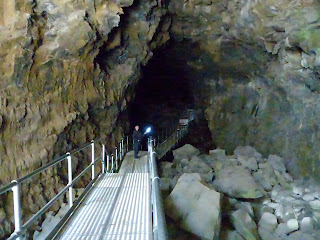
After going up, our next stop was underground.  Lava River Cave is almost a mile long, making it Oregon’s longest lava tube.  The cave is not lit, so you have to take your own lights—and it’s really dark down there!  (Take two, just in case.)
The entrance is full of chunks of rock, part of a collapsed corridor.  I kept looking up.  To get across the blocks, they’ve built a metal walkway, with railings.  I really hated it when they stopped because I had liked something to occasionally hang on to.  In some places the walls are slimy and not fun to grab. (Ick!)
After the first section, the cave smooths out, but there are some places where you have to step down or around.  I was surprised to find all the sand on the floor, but the ranger we talked to after we got back said it was all washed down from the end of the tube.

It’s tricky to hold a light and then hold still enough to take pictures.  George’s flashlight has an LED bulb, mine doesn’t.  His showed up better than mine did, but it’s blue on the walls.  Mine's more yellow.

There’s one section called “Sand Gardens” where sand has accumulated when sediment is washed down through cracks in the roof.  As water droplets fall on the sand and erodes it, it makes tiny castle-like spires.  Use your imagination because my light seems to have none.
There’s a sign at the end of the trail where we turned around and headed back.  I don’t think George bumped his head as much as he does in some caves.
Pretty interesting.  Maybe next time we’re in the area, we’ll drive out to the Newberry Caldera to see the rest of the park.  After all, just because you’ve seen one volcanic feature at one national park, it doesn’t mean you won’t see something completely different somewhere else--even in the same park.

NOTE:  * I made up that number—please don’t quote it to anyone who knows anything about Oregon geology.  I suppose it might actually be higher...or lower...

Interested in more pictures of Newberry NVM?  Go here:  Newberry National Volcanic Monument