
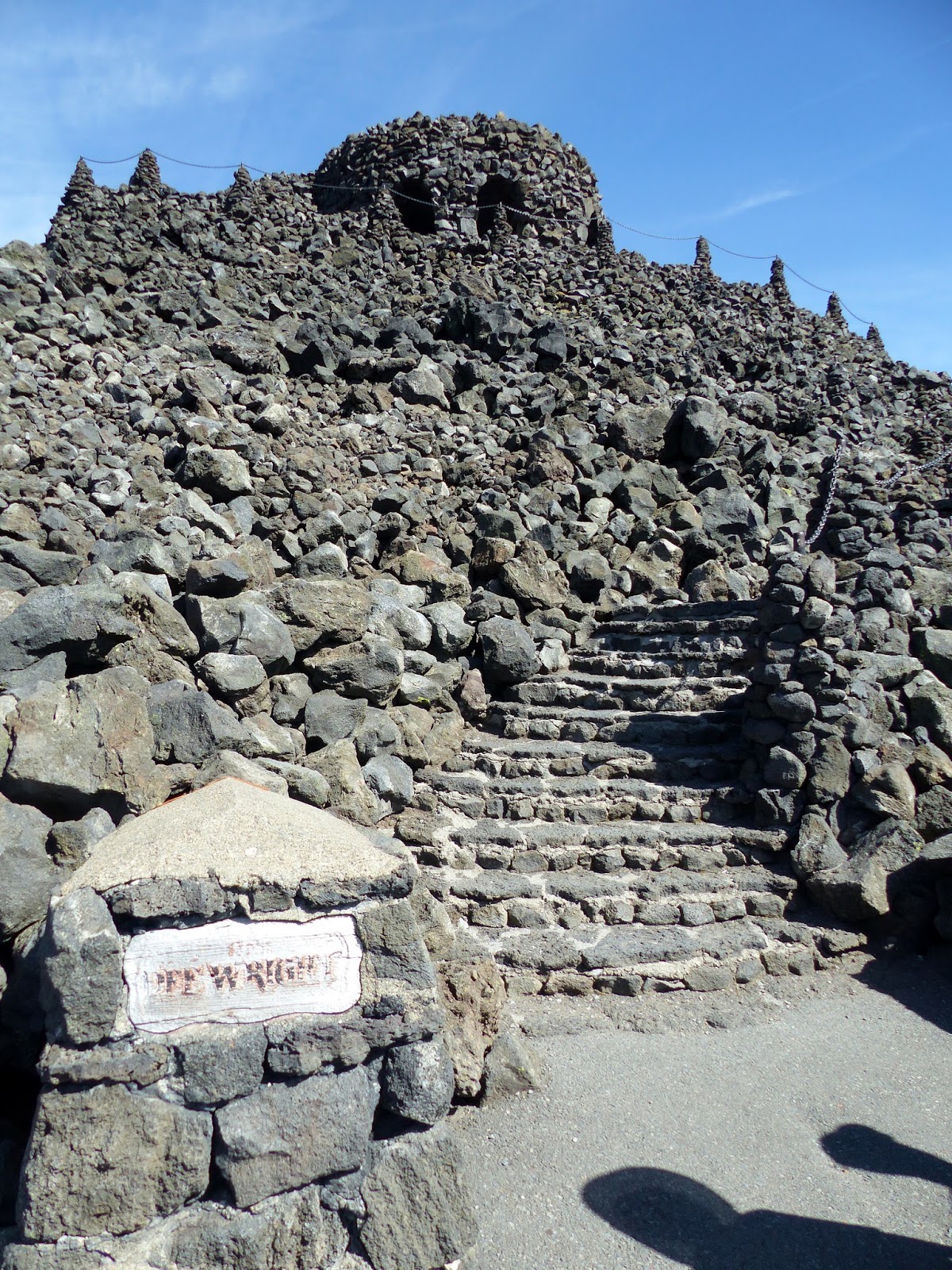
Larry and Carolyn took us to Dee Wright Observatory at another Oregon lava flow—this
one at the summit of McKenzie Pass on Highway 242. Dee Wright, a forest service worker who as a
CCC foreman started installation of a viewfinder among the lava fields. He died before the project was completed so
they named the observatory after him. (Wonder what they called it before? Wonder if he actually cared?)


Built of black lava rock atop a ridge of lava, it’s camouflaged as the remnant of an old volcano dome, with just the plug showing. The windows could be vent holes. Or not...

 A group of people coming down the steps looked familiar. Turned out the four of us knew the four of
them! Two couples we’d met in Arizona one winter live in Bend and were out for a drive with other RV
friends. It always amazes me that as big
as this country is we can still meet people we’ve met somewhere else. Wonder what the odds of that actually happening
is? I think we should keep traveling and see who
else we’ll meet. I'll call it "Random RV Encounters".
A group of people coming down the steps looked familiar. Turned out the four of us knew the four of
them! Two couples we’d met in Arizona one winter live in Bend and were out for a drive with other RV
friends. It always amazes me that as big
as this country is we can still meet people we’ve met somewhere else. Wonder what the odds of that actually happening
is? I think we should keep traveling and see who
else we’ll meet. I'll call it "Random RV Encounters".
After all the greetings (and more pictures), they continued
on their excursion and we headed upstairs to the observatory. Inside, each window is a viewfinder to specifically identify individual mountain peaks. Under the window is a concrete plaque with the name of a peak--which you could sometimes still read. The windows are aimed at individual mountains in the distance. On a clear day you can see all the way to Mt.
Hood, about 80 miles away. The sky was
blue and beautiful, but it apparently wasn’t good enough for Hood to put in an
appearance. Actually I thought I could
almost see it through the haze, but that might have been my over-active
imagination. Maybe not....my imagination tends to
create bears instead of mountains.


Back outside, and up a few more steps is a big bronze compass with
the names of all the peaks on it. That’s two of the Three Sisters (and Little Brother) over 5 miles away. "Sister" seems to be a very popular name for mountains in the US.

The Lava River National Recreational Trail is a simple
half-mile loop. Simple because it’s
paved and you don’t have to clomp your way rock by rock through the lava
field. Personally I would have preferred the clomping,
but nobody else would have.

 There are interpretive signs along the trail,
pointing out interesting features. One
of the first was a wagon route across the lava! Why would anyone think that it would be a good idea to haul a wagon across this stuff? I admit their trail looks a little flatter and smoother than the adjoining lava field, but this seems downright stupid! I can imagine crossing the flat, hot, boring plains to get to Oregon. I can imagine crossing the Rockies. But a huge lava field? Absolutely NO WAY!
There are interpretive signs along the trail,
pointing out interesting features. One
of the first was a wagon route across the lava! Why would anyone think that it would be a good idea to haul a wagon across this stuff? I admit their trail looks a little flatter and smoother than the adjoining lava field, but this seems downright stupid! I can imagine crossing the flat, hot, boring plains to get to Oregon. I can imagine crossing the Rockies. But a huge lava field? Absolutely NO WAY!There’s one area with a big wall of lava towering over the trail.

The lava field isn't completely barren--there are plants growing in some of it. Tenacious, determined, stubborn ones, but trees do grow here. (I think that thin in the foreground looks like it should be somewhere tropical.)
 Interesting walk through a tiny portion of the 65 square
miles of lava field protected by the forest service. We chose not to continue the rest of the McKenzie Pass-Santiam Pass Scenic Byway loop and headed back to Sisters for lunch. That
would be the town of Sisters, not the mountains.
Interesting walk through a tiny portion of the 65 square
miles of lava field protected by the forest service. We chose not to continue the rest of the McKenzie Pass-Santiam Pass Scenic Byway loop and headed back to Sisters for lunch. That
would be the town of Sisters, not the mountains.

More pictures here: Dee Wright Observatory

Post a comment.
Post a Comment
Please leave comments here: