 For a change, we stayed a week at Worldmark condo at Running Y Ranch near Klamath Falls, Oregon. I went for a walk around the golf course. (That doesn't mean I was golfing; there's an asphalt walking trail circling the golf course.) I was looking at the scenery and not where I was going, got off the edge of the blacktop and went for a tumble, landing on my elbow. It was only a hair-line fracture, but it hurt--that's why there's a sling on my arm.
George says I’m supposed to watch where I put my feet, not just where I’m going to be. (Or words to that effect.) It's slowed me down, but didn’t stop most of the plans for this segment of the trip. Three days later we headed to Crater Lake National Park.
Hard to believe we hadn’t been to Crater Lake yet. (Actually, we had—just not since we’d retired,
so I don't count it.) They close the
road around the lake November 1st (or when first snow falls) and don’t open it
again until June or July (or when the snow's all gone.) Our timing
north and south had been out of sync with the weather. Although I can sympathize
with avoiding the snow, I didn’t want to miss the full Rim Drive--even if I had to do it while wounded.
We wandered around Rim Village for an hour, checking out the
overlook, Visitor Center and lodge. There’s a little historical display inside
the lodge that’s pretty cool. (Did you know there was a waltz called “Crater Lake” written in 1932? Me neither. If you turn the page, it plays the tune. Pretty sure I never danced to it.)
This deepest lake in the US is almost a perfect circle, if you ignore the squiggles of the bays and coves, which truly makes the crater visible. Rim Drive is a 33-mile long scenic drive, with the unbelievable blue of the water usually visible on the right if you go clockwise. (That would be MY side of the truck; planning is always important.) It’s hard to decide whether the blue of the sky or the blue of the lake is prettier.
This deepest lake in the US is almost a perfect circle, if you ignore the squiggles of the bays and coves, which truly makes the crater visible. Rim Drive is a 33-mile long scenic drive, with the unbelievable blue of the water usually visible on the right if you go clockwise. (That would be MY side of the truck; planning is always important.) It’s hard to decide whether the blue of the sky or the blue of the lake is prettier.
Discovery Point is where a gold prospector accidentally
discovered what he called “Deep Blue Lake”.
Admittedly that shade's not precise, but the blues around here jumbles the names on the color wheel in your brain.
It would probably be worse for a prospector who’s looking for something
else that glitters in the sunshine. Anyway, he forgot how to get back to it. Now it's a national park.
The National Creek Complex fire that started with a
lightning strike on August 1st was full-contained, but still
burning. About ¾ of the almost 21,000
acre fire is within the park, making it the largest fire in park history. You
can see the smoke off towards the mountains.
At 7,865’, Cloudcap Overlook on the east side of the lake is at the end
of the highest paved road in Oregon. (Clouds and winds are generously included.) By the
time we got there, my arm was pretty achy and I was running out of steam. I might have been getting a little crabby
too...I’m sure George would share his observations.
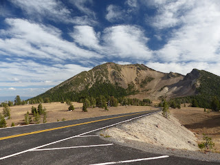
Mount Scott at 8,929’ is the highest point in the park. I
don’t think it’s terribly impressive, but I’d been looking at the lake, which is.
This isn’t Bryce Canyon, but there’s one place that evokes
the colors and shapes of the southwest. The next overlook has a view of Pumice Castle, a layer
of orange pumice rock that eroded into the shape of a medieval castle. Sort
of...
Phantom Ship is the other island in the lake. They say it resembles a small sailboat; I
think it looks more like a castle than Pumice Castle. It’s as tall as a 16-story building, a whole lot taller than it looks from up on the rim.
Pinnacles Overlook is a 6-mile detour east from the Phantom
Ship Overlook. The Pinnacles are fossil fumaroles where volcanic gases rose up through
a layer of ash, cementing it into solid rock, then eroded. A lot of them look like needles, but I like
the ones where the point is broken off. There’s a trail, but I was wiped.
Last stop was Vidae Falls.
We stopped, took two pictures and I was done.
(I mean really DONE!)
I think it’s probably prettier than I noticed.
(I mean really DONE!)
I think it’s probably prettier than I noticed.
I might not have felt great, but I could still handle a camera, so click for more pictures of Crater Lake.


Post a comment.
Post a Comment
Please leave comments here: