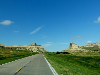
 Nebraska's pretty flat...mostly. There are some odd geologic formations here and there in the west that made wonderful landmarks for travelers on the Oregon Trail. We stayed at a campground in Gehring near Scotts Bluff National Monument. We could see it from our RV, and some other rocks and bluffs as well. The angle wasn't the same as on the posters so I wasn't entirely sure which one was named Scott...I'm sure I would have flunked Pioneer Woman 101.
The road to the monument, uniquely named Old Oregon Trail, goes along the route the emigrants followed. There are places along it where you can see the old ruts. It cut between Sentinel Rock on the left and Eagle Rock on the right, with part of Scotts Bluff on the far right. (It wasn't paved then.)
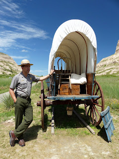
At the Visitor Center we saw the video. Just as soon as we finished, they made an announcement there was going to be a ranger talk out front. We met him out by the covered wagons. This wagon was made by Studebaker--they made wagons before they made carriages before they made cars!
This one's a Murphy Wagon. The little round thing hanging down on both wagons was the grease bucket, to keep the wheel hubs greased. The smaller wheels in front made it easier to turn. The big wheels made it easier to go over uneven ground. I used to think that the emigrants rode in the wagons. Nope, they walked beside them. The wagons didn't have springs and wouldn't have been very comfortable.
The wagons only measured 10' x 4' but still managed to carry over a ton of goods and supplies. I also used to think (until 3 days ago, actually) that the wagons were loaded all the way up so they could be stuffed full. Nope, they tried to keep the load below the canvas, to keep a low center of gravity and to keep the canvas from getting torn. (It's disheartening when what you think you know gets proved wrong by actual facts...) This heavy Conestoga Wagon wasn't used by the pioneers but was used to haul freight (like on the Santa Fe Trail).
And mostly they preferred oxen, even if they could only go about 2 miles an hour!!! Some of the really poor folks on the Mormon Trail couldn't afford any livestock, and just used handcarts. (Please NOTE: picture below is for demonstration purposes only; there's absolutely no way I'd consider doing such a thing for real! I'm much too fragile and delicate.)
 |
| Tunnel 1 |
 |
| Inside Tunnel 2 |
 |
| Coming out of Tunnel 3 |
George and I did walk up the 1/2 mile long North Overlook Trail. The Badlands are just below, and in the distance across the North Platte River is Scottsbluff (all one word).
Although half the trail was downhill, it must have worn George out because he opted to sit in the truck while I walked up the to South Overlook. Besides a closer view of Saddle Rock, you can see the Visitor Center, and both the trail and the road up to the bluff. You can even see the first tunnel if you squint.
And I saw these really neat wildflowers. They're not open all the way so I can't figure out what they are. If you know, I'd be happy to share.
More pictures here: Scotts Bluff Natl Monument


Post a comment.
Post a Comment
Please leave comments here: