September 30, 2012

9/23/12 - Grand Canyon NP (North Rim)

The North Rim of the Grand Canyon gets only 10% of the visitors that the South Rim does.  We were at the South Rim last November.  Let the crowds go south--we headed to the North Rim!

It's about 10 miles across the canyon, "as the crow flies", though I've never seen one fly a straight line.  By road, it's 215 miles; not a lot of bridges across the Colorado River. The North Rim is about 1,000 feet higher so it's cooler than the South Rim.  And I think it's a lot prettier.  (Of course, that could be because there are fewer people and you can actually see it--see paragraph 1.)
The approach to the park is through open range and a high meadow surrounded by forest.  Various signs warn to be on the lookout for cattle, elk, deer and bison (only they're not buffalo--it's a beefalo herd...which we also didn't see).  I think we saw a cow or two, but none of the good stuff. 
After checking out the Visitor Center, we headed out behind the Lodge to Bright Angel Point.  If anybody asks, it's really a long way down! 


While we were having our picnic, I saw a condor looking for his own lunch.  Just imagine a really ugly bird with a 9 foot wingspan flying in lazy loopy circles cruising for carrion.  George thinks it was a raven.  It was a condor!!!  But I didn't get a good picture.

We took the Scenic Drive to Cape Royal.  There's a little detour to Angels Window--check out the Colorado River through the window!  The trail leads right out to the top of the arch. 
We stopped at Walhalla Overlook, and waited for a rain squall to go past.  It was definitely worth the wait!
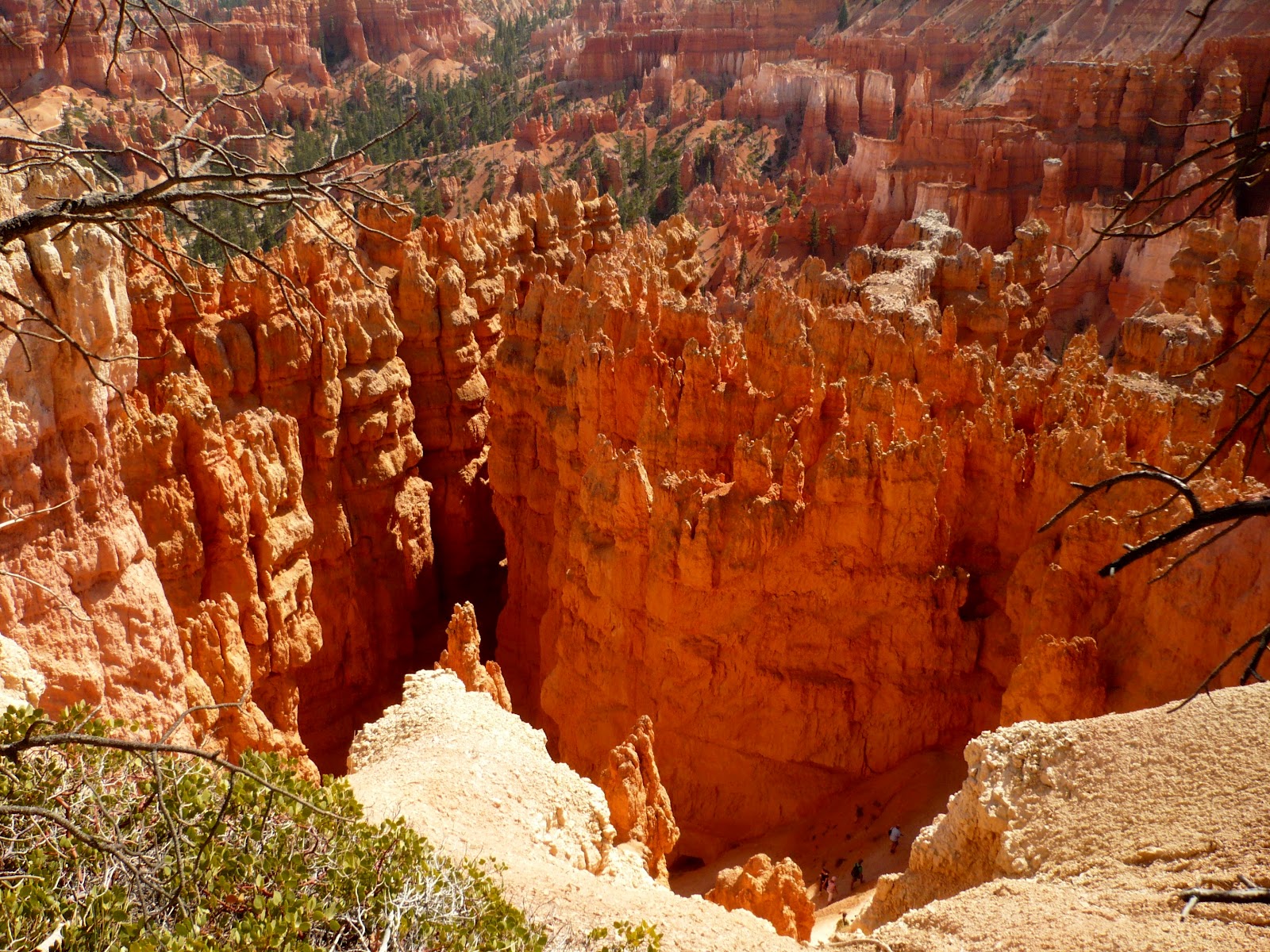
From the Vista Encantada overlook, you're supposed to be able to see all the way to the Painted Desert.  Of course, it requires a clear day, which we definitely didn't have.  The vibrant red canyon walls are from iron oxides.  (Since we've been on our trip, I've decided that half the country is rusting away--and the other half is blowing away!  See it while you still can!)
We ended at Point Imperial--this is the highest viewpoint at the Grand Canyon.  Even without bright sun and blue skies, I really liked this one.
 Link to more pics of the North Rim

September 27, 2012

9/20/12 - Cedar Breaks NM


Cedar Breaks National Monument got its name when some settler referred to nearby junipers as cedarsBreaks is a term for "badlands", but I couldn't find it in my dictionary.  (I do rather like what the Paiutes called it:  u-map-wich, "the place where the rocks are sliding down all the time."  Wouldn't that be a great park name?)

Cedar Breaks is a big amphitheater, 2,000 feet deep and 3 miles in diameter.  You look across ridges and down into canyons from just four overlooks along the scenic drive.  Unlike Bryce, there are no trails other than on the rim--and no place to put them! 
 
 
The 5-mile drive through the park is definitely in highcountry!   It's already getting cold at night in this part of Utah, and the quaking aspens think it's fall already.
 
There are two trails up on the rim, but after the hike at Bryce the day before, George was not at all interested in even a short hike!

We met a guy from New Zealand who's touring the Grand Circle on a motorcycle. I told him that gas was expensive in Torrey, where he was heading next. He said, "Oh, no! It's cheap!"  Fuel here is 1/2 the price he'd have to pay at home.  Frame of reference, I guess...


We drove 2 scenic highways to and from Cedar Breaks.  To see pictures from there and more of Cedar Breaks NM, follow this link:  Cedar Breaks NM

9/17/12 - Bryce Canyon NP

Bryce Canyon National Park seems to be a recurring theme in my life.  First time I was there, I was 12.  George and I visited on our honeymoon in 1990.  Now we're retired and back again.  For some reason, it appears that erosion has affected me more than the canyon.  (I hate that part!)


We took the shuttle to Bryce Point where we got our first look down from the rim at the hoodoos and grottos.  This is where you let your imagination run wild.  It's even better than clouds--except the rocks don't usually move.
Bryce Point

The Grottos


After the requisite oohing and ahhing there, we walked along the Rim Trail to Inspiration Point.  (That's either 1.5 miles or 1.3 miles, depending on which sign or map you read.)  Mostly it's downhill--although at over 8,000' you can even get a little huffy-puffy when it's flat.  In the desert--even high desert, you have to be sure to stop frequently and drink lots of water!  George carries the backpack; I tell him when I'm thirsty.
 
Look close to see the trails waaaay down below.
I was inspired at Inspiration Point by hoodoos that look like castles:
At Sunset Point, you can see the Silent City, provided, of course, you have a clue which spires and hoodoos someone might have identified as a cityscape.  Is this it??  Maybe the sun has to be setting??  (I'll just google it!)

Two days later we went back to Bryce.  This time we ignored the shuttle buses and drove down to Rainbow Point at the south end of the park.  Actually, that's UP to Rainbow Point--at 9,115 feet, the elevation is 1,200 feet higher than the Visitors Center!
Rainbow Point


Yovimpa Point
Heading back north, if there was a viewpoint or a turnout, we stopped.  Here are a few pics--to see more, be sure to follow the link at the bottom of the post.

Ponderosa Point


Natural Bridge
Poodle at Agua Canyon
We even stopped once when I saw a small herd of pronghorrn antelope in a meadow below the road.  That caused a whole bunch of other people to stop.  At least it was something worth looking at, and not Canada geese that people were blocking traffic to see at Yellowstone! 


We had hiked the Navajo Loop Trail when we were on our honeymoon.  We're only 22 years older, and we did it again! 

It's a steep hike down into the canyon by more switchbacks than I've ever seen. 


When you finally get to the bottom, the trail goes through a slot between two hoodoos.  I like the trees that grow right there. 
 
Eventually the trail starts going up--and up--and up.  More switchbacks and lots of cool formations. 
They say it's all about perspective. You can bet your perspective sure changes when you're looking down into the canyon, or down in it looking up, or while you're climbing looking at the hoodoos straight on. 

Link to more pictures of Bryce Canyon NP.

September 16, 2012

9/13/12 - Capitol Reef NP

The Castle
Capitol Reef National Park is a relatively new park (1971).  That's at least new enough that I (a) hadn't heard much about it and (b) can't remember the name most of the time.  I know it begins with "C", and I know it's not Canyonlands or Cedar Breaks.  I just ask George--most of the time he remembers.


Capitol Reef is in the Waterpocket Fold (cool name,huh?) which is a wrinkle in the earth, probably a wrinkle in time too.  Utah Hwy 24 runs right through it, so before we went to it, we'd already been there.
The Mormons had a little settlement in Fruita--remnants of their fruit and nut orchards are still there (if you can call 3,000 trees remnants). You can pick fruit in the orchards, which is a unique thing to do in a national park. Anything you eat there is free--any you pick and take with you has a nominal fee.
There are ridges --called reefs, canyons, domes and bridges, all just made for gaping, pointing and photographs.  Erosion is the name of the game in this park.


The layers of rock eroded differently than in other parks on the Grand Circle, so there are cliffs and slopes, and a geological spectrum of colors.  Some of it looks pretty substantial, and other parts look like it could will crumble in a good rainstorm. 

There are round black rocks scattered across the landscape too--weird basalt boulders left over from a long-ago and far-away volcanic eruption.
Oh, and let's not forget the waterpockets!  Makes the walls look like Swiss cheese, and some are so big you can fall into them.


September 11, 2012

9/8/12 - Corona Arch Hike & Arch Jump

This was supposed to just be a hike to Corona Arch--instead it turned out to be an experience we couldn't have anticipated. 
Weird place for a cairn


We followed the directions--went up the hill and registered, then crossed the railroad tracks to follow an old roadbed up through a gap in the rim.  Then we had to follow rock cairns through a sandy pass and then down to the base of the cliffs. 


Safety cable by the steps in the slickrock


There was a safety cable to help traverse the sidehill.  A second cable gave you something to hang onto as you climbed up the steps cut into rock. 


Then there was a little ladder to get on top of the ledge.  From there it was a walk across slickrock to the arch. 

George contemplating the ladder
Actually there are two arches:  Bow Tie Arch is adjacent to Corona Arch.
Bow Tie Arch (on left) and Corona Arch
Bow Tie Arch


Corona Arch
(Look close--there are two guys up on top.)
We stopped in the shade of a big rock alcove across from Corona Arch before we did the final bit past Bow Tie and on to Corona when we heard yelling.  It was like we were in a big amphitheater, so we could hear really well.  Suddenly we realized that someone had jumped off the top of the arch on big long ropes, and was swinging under it!!!  (Idiots!)
Just getting ready to jump off the top
From where we were, we could hear everything they were yelling (sometimes screaming, sometimes cursing). Apparently some of them had done this before, and some were brand-new at it. (I've heard those words before but not quite in that context.)
There he goes!  NO WAY could I do this!
We stayed and watched for a while before we did the final walk around the cliff to Corona. George talked to one guy who wasn't part of the original group--he and his friend had come up to rappel from the top and were invited to jump.  He said that the first 5 guys got to the parking lot at 2:00 am and started carrying their gear to the arch. They put pitons in the rock, did all kinds of safety checks including throwing a backpack full of rocks off to make sure it would handle the weight.  They wore safety harnesses and an extra rope. They don't go straight down like a bungie jump, but take a run that takes them out from the arch, then they swing back like a pendulum. They're really careful about ropes too. (I still think it's scary!)

Swinging under the arch
   

...and back the other way, upside-down!
 

I thought it was pretty cool (stupid, but cool!). George wasn't as impressed as I was.  I could tell because he took at total of 35 pictures. I took about 100 more than that, but edited them down to 94, including the video...Certainly makes for fun memories.
At the bottom they have to get the ropes straightened out
There are more pictures on Flickr. 
    Link to Corona Arch Hike
    Link to Corona Arch Swing

I even took a video. We were too far away when I recorded it but it's still pretty impressive to see what they were doing.