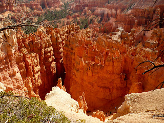
We took the shuttle to Bryce Point where we got our first look down from the rim at the hoodoos and grottos. This is where you let your imagination run wild. It's even better than clouds--except the rocks don't usually move.
 |
| Bryce Point |
After the requisite oohing and ahhing there, we walked along the Rim Trail to Inspiration Point. (That's either 1.5 miles or 1.3 miles, depending on which sign or map you read.) Mostly it's downhill--although at over 8,000' you can even get a little huffy-puffy when it's flat. In the desert--even high desert, you have to be sure to stop frequently and drink lots of water! George carries the backpack; I tell him when I'm thirsty.

 |
| Look close to see the trails waaaay down below. |
I was inspired at Inspiration Point by hoodoos that look like castles:
At Sunset Point, you can see the Silent City, provided, of course, you have a clue which spires and hoodoos someone might have identified as a cityscape. Is this it?? Maybe the sun has to be setting?? (I'll just google it!)Two days later we went back to Bryce. This time we ignored the shuttle buses and drove down to Rainbow Point at the south end of the park. Actually, that's UP to Rainbow Point--at 9,115 feet, the elevation is 1,200 feet higher than the Visitors Center!
.JPG) |
| Rainbow Point |
.JPG) |
| Yovimpa Point |
.JPG) |
| Ponderosa Point |
 |
| Natural Bridge |
 |
| Poodle at Agua Canyon |

We had hiked the Navajo Loop Trail when we were on our honeymoon. We're only 22 years older, and we did it again!
It's a steep hike down into the canyon by more switchbacks than I've ever seen.
When you finally get to the bottom, the trail goes through a slot between two hoodoos. I like the trees that grow right there.
Eventually the trail starts going up--and up--and up. More switchbacks and lots of cool formations.
 They say it's all about perspective. You can bet your perspective sure changes when you're looking down into the canyon, or down in it looking up, or while you're climbing looking at the hoodoos straight on.
 Link to more pictures of Bryce Canyon NP.
.JPG)
.JPG)


