April 17, 2015

4/15/15 - Bandelier NM

Before you get your expectations up about this being a battlefield, let's get this out of the way right now. A bandolier is "a shoulder-belt with loops or pockets for cartridges".  Bandelier National Monument is named after anthropologist Adolph Bandelier, whose work established the foundation for much of modern southwestern archeology.


So the park is about the ancestral pueblo people who lived here until about 500 years ago.  Don't cliffs like this just make you want to build a house here?  (Assume there's a History Alert. We're talking about pueblos and cliff houses here.)
In the Visitor Center, we watched the video and checked out the exhibit room--which is nowhere as good as the museum at Pecos NM. Then we headed outside to the Main Loop Trail on the way to the cliff dwellings.
Along the way was Frijoles Creek. (In Spanish, that's "little river of beans"--which cracked George up! See? He does have a sense of humor!)  Looks pretty benign here, but in September, 2013, they had the largest flood in park history. More on that later.
The Big Kiva is quite a bit larger than the one we saw at Pecos NM.  You can see where some of the wooden pillars that supported the roof were.  The kiva was the community's center.  I think the rectangular openings along the wall might be for ventilation--kivas would be pretty smokey.  Even the experts don't know what the rectangular holes in the floor were for.  (If you know, please correspond directly with the National Park Service.)
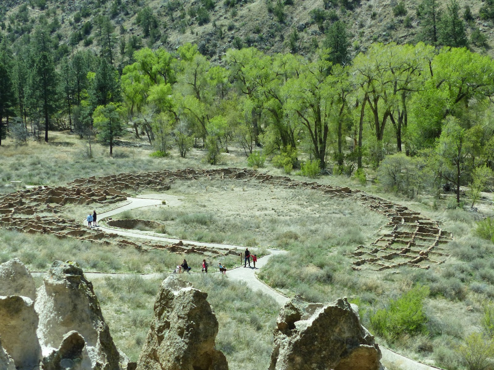
The trail goes right through the village of Tyuonyi.  Apparently not everyone liked the high life. The houses were one or two stories high, with about 400 rooms for 100 people.  They had three kivas. When we get higher, there will be more pictures of the village to give a better perspective. 
As the trail circled towards the cliffs, it started to look interesting.  The cliff is made of volcanic tuff, which contrary to it's name is very soft stuff.  Ideal for do-it-yourself-cave-makers.
We'd already been told we could go into any dwelling that had a ladder. But first, there are stairs to be climbed.
 
These cave rooms, called cavates by an early archeologist, were dug out of the cliff wall with stone tools. More labor intensive than the homes in the village below, they probably cost more. Inside the lower walls were plastered and painted, and the upper ones were smoke-blackened to keep the volcanic tuff from crumbling.
Talus House was reconstructed for the tourists with no imagination. As you walk the trail in front of the cliff, there are a lot rocks laid in rectangles, so you can often see where they were.
Here's another ladder--that means I get to climb it and go into the cavate.  It's a little bigger inside than the last one.
                      
From up here you can get a good view of Tyuonyi village.
So then there are more steps to more ladders to Cave Kiva.  This cavate has been reconstructed for us. It's big enough for George to stand up in for a change.  The beams near the ceiling were for loom supports, and the little holes in the floor were for anchors to keep the weaving straight. The graffiti is modern and rude. They have to replaster and smoke the kiva on a regular basis to get rid of it.
 
 
Of course there were more steps--I'm telling you, touring national parks is not for the faint of heart! Some of the trails and steps were built by the CCC.
Now the trail goes right next to the cliff wall.  This series of dwellings is called the "Long House".  Here you can see where the outside house foundations are.  The parallel holes in the cliff wall were for roof supports.  You can see this one had two or three stories.
Question:  Did this big chunk of rock fall before or after the houses were built?  George thinks it was there a long time before they built the house.  I think it crashed down on it. Either way, it sure makes you think.
Count the rows of holes for number of stories.  Sometimes people would stand on the top roof and carve petroglyphs into the cliff wall. (They're very hard to see, even life size and in person.)
After leaving the cliff where the Long House was, the trail crossed the creek.  There you had the option of going back to the parking lot or turning right to go to the Alcove House. We turned right, heading to the base of that cliff way over there.  Then we'll climb a series of four ladders.
George is at the top of the first ladder.  You can just barely see the next 3 ladders.
Below, George is waiting for someone to come down Ladder 2 before he can go up. Then you can see what it looks like from the top!
       

Once you get to the top, you can see the kiva in Alcove House, the size of the alcove, and the roof pole holes by the cavates.

Then it's time to come back down.  FYI, the ladders are bolted for us way better than the Indians' ladders were.  Can't you just see the little pueblo kids scrambling up and down them?  I hung on really tightly.
Oh, yeah--I forgot the caution sign by the first ladder. But now we've been there, done that!
I probably put in too many pictures for this blog posting, but it was kind of fun.  If you're really a glutton for punishment, there are more pictures here:  Banderlier NM

4/14/15 - Pecos NHP

Unless you've been to northern New Mexico, you've probably never heard of Pecos National Historical Park.  (I actually thought Pecos was in Texas, and it is--this is another one.) What the two towns have in common is the Pecos River, sort of that river-runs-through-it theme.

History Alert:  You've got to assume that a park that has Historical as its middle name isn't about geology. Just look at the pictures if you want.

The museum in the Visitor Center documents the history from archaic trading tribes who eventually prospered and consolidated to build a town, to Spanish conquerors and missionaries to a Civil War Battlefield.  I learned more than George did because he was talking to the Visitor Center volunteers while I was wandering this surprisingly large museum.
A long time ago there were Pueblo Indians who were basically traders.  By 1450 they built a huge pueblo that housed about 2,000 people in a 5-story fortress.  Life was good. Then Coronado came looking for the Cities of Gold...didn't find them in Kansas (duh!) so he left.  Sixty years later the Spanish came back with missionaries and built a a huge adobe church south of the pueblo.  The Pecos Indians put up with them for awhile, then revolted and destroyed the church.  Twelve years later the Spanish (obviously a stubborn breed) came back.  This time they built a much smaller church, but eventually everyone left and the pueblo and the mission decayed to what it is now. (If you want to fill in the very large blanks above, check out the museum.)  

The trail starts behind the Visitor Center and goes up past that rock wall and around the hill to the mission.  The hill isn't a standard hill; it's where the original pueblo stood.  Now it's crumbled and filled over with dirt.  (If you wonder how a 5-story village could be covered up in a few hundred years, you've never been in New Mexico in the springtime.)
This rock wall was part of the pueblo wall.  Takes a lot of rock to built a wall to protect 2,000 people!
Pueblo Indians build kivas for religious ceremonies.  They're sort of a pit house, with a cover.  This one has been rebuilt. The thing that looks like a sundial is a ladder sticking up out of the door in the roof down into the kiva.  We climbed down...it's pretty cool.  The rocks by the ladder are actually a deflector for the fire pit, which I think is pretty clever.
We kept walking up the hill past small pueblo ruins.  The trail guide says 2/3's of the pueblo remains in the unexcavated mound.  (It's difficult around ancient ruins to be able to tell the difference between a rock and a rock used for a house.  These pretty much look like plain rocks to me.  I guess that's why the archaeologists don't excavate it all.)
Around the corner and a little further on are the ruins of the last church built in the footprint of the first one.   (I think both churches were named "Mission of Our Lady of the Angels of Porciuncula", but don't quote me on that.  In fact, you probably shouldn't quote me on much of anything.) The info picture shows it better than I can describe it.  The white overlay on the picture of what's there now shows how big the original mission was.
The first church was destroyed during the revolt, but the second doesn't seem to be fairing well either. Adobe isn't the most durable of building materials.
It was really windy--George had to hang on to his hat!
The south pueblo ruins are right next to the church.
There's a kiva.
And these rocks are neither house nor ruins.  They're cobblestones in a turkey coop. Apparently the cobblestones were easy to clean and drain, although I didn't see any hoses. The cages went on the other side.  The Pecos used turkey feathers for blankets.  (I had to think about this a bit.  I thought they pulled all the little feather pieces off the shaft and then spun them like wool, but when I checked on Google, they look like little feather tufts sticking out all over.  Hmmm.)
Remember I said there was a Civil War battlefield here too?  (If you didn't, that's okay, it's not a test.) The Battle of Glorieta Pass took place near here.  We didn't have enough time to go check it out, but we did stop at the National Historic Landmark sign.  Perhaps another time...  

Click the link for more pictures at Pecos NHP.

March 31, 2015

3/27/15 - Grand Canyon NP, South Rim (again)

Back to Grand Canyon National Park--this time with friends who had never been there.  I figure everyone should see it at least once. There were lots of people, but it's definitely not as crowded in March as it is during the summer.

I got a new camera for Christmas.  It has a lens that goes from super-wide to a 600mm telephoto; the Grand Canyon has opportunities for both.

First stop, as usual, was the Visitor Center.  (For a change we didn't watch the movie.)  We were told to take the blue bus to the red bus.  I thought we could handle that, but I took the map anyway.
We got off the blue bus at the Train Depot stop to see Grand Canyon Village. First detour was Hopi House, then outside and behind the building for a look at the canyon.  I could even see the people riding mules down on the trail.  (I'm going to like this camera!)


We had lunch at the El Tovar Hotel, then it was back to the Train Depot.  There was a train in, but we couldn't see the locomotive OR the people, just a string of interesting cars. Maybe next time...
First stop on the Red Train was Trailview Overlook.  From the overlook, you can see Bright Angel Trail, squiggling downhill to the bottom.  It's not quite a mile straight down, and about 10 miles across to the North Rim.  Of course, those are averages...all distances increase exponentially if you hike instead of just look.
Next stop was Powell Point.  

Then Joyce rode the bus to Hopi Point while Gary, George and I walked the Rim Trail.  That overlook faces a different direction and we could see the Colorado River below.  (Or at least I could--this is zoomed quite a bit.)
Last bus stop before we headed back was Mojave Point.  Another viewpoint, another direction, another view.  The Grand Canyon looks a little bit different every time you look.  And friends make it even more special.
I learned some things about my new camera today.  Mostly I learned that the filter I had on wasn't the best one, and that I need to learn a whole lot more about the settings, automatic or not!  I need to dig out the instruction manual again. 

More pictures of the South Rim here:  Grand Canyon South Rim (Revisted) 

We'll be heading out on our 2015 trip by mid-April.  First stop for pictures will be places around Santa Fe, New Mexico.