March 31, 2011

3/29/11 & 3/31/11 – Jean Lafitte NHP&P

Like John Day Fossil Beds, Jean Lafitte National Historic Park & Preserve is another park that’s comprised of various sites scattered all over the place.  Each one has a different theme--that should probably be focus—but we are, after all, discussing a park.  I’m not entirely sure why the park service decided to name a park after a pirate, but maybe politicians felt a certain connection??
There are 6 Visitor Centers in southern Louisiana.  We visited 3 of them:  Acadian Cultural Center in Lafayette, Chalmette Battlefield and National Cemetery in Chalmette and Barataria Preserve near Marrero.
3/29/11 - Acadian Cultural Center:  We wandered around the museum looking at exhibits on the Acadian culture until time for the next showing of the movie about how the Acadians from the Canadian Maritimes came to be Cajuns in Mississippi.  (Blame the British!)  Then we headed to Breaux Bridge.  (Note:  I’m doing a separate blog for the Cajun Swamp Tour.)
3/31/11 – Chalmette:  Chalmette Battlefield was the site of the Battle of New Orleans in 1815, and the Chalmette National Cemetery has over 15,000 graves of veterans from the Civil to Vietnam wars.  We used the GPS and ended up at the cemetery but couldn’t figure out where to park.  A ranger explained to us where the Visitor Center was, let us drive through on a maintenance road.  We came in from the wrong end of the road, but headed to the Visitor Center.  We checked out the exhibits, then watched the video about the battle.  We learned a whole lot more about the importance of the battle there than we did in High School!  There’s a self-guided tour that goes all around the battlefield, so we hopped in the truck and went back to see the American ramparts and cannon.  The US cannons are/were painted in US regulation colors:  sky blue and black.  I guess if the British are wearing red coats, then painting the canons light blue fits right in.  Only one canon was black (actually Spanish red and black)—a 32 pounder that had been commandeered from a Navy ship. 

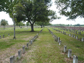
We saw the battlefield from both the American and the British side.  Not as large as you’d think—and yet it is. On one side is the Mississippi.  The field is really swampy and the day we were there it had standing water in several places.  Must have been a terrible place to have to cross.  I’ve still got chunks of the song in my head…let me know if you can remember more than the first verse, the chorus—and of course, the part about the gator!

The cemetery location was part of the battlefield.  It was established as a burial place for Union soldiers who died in the Gulf area during the Civil War.  Only 4 soldiers from the Battle of New Orleans are buried there.  It’s a quiet peaceful place.
 3/31/11 – Barataria Preserve.   George really got into Chalmette, and I had to remind him that we still had another place to go.  From the park, we drove to the Chalmette Ferry—right next to a big refinery—to cross the Mississippi.  Obviously we Washingtonians know ferries—this was definitely not the Puyallup!  I told my son that we rode backwards across the Mississippi and he wrote back Don't you know that you cross the Mason-Dixie timeline when you cross the Mississippi backwards and screw up the space-time continuum and could reverse the entire Civil War and those Damn Yankees could actually LOSE if you keep that up?"  So let me explain about the Chalmette ferry: unlike Washington ferries, where you drive on one end and drive off the other end when it docks, this little ferry only goes one direction. You drive on and loop around like a u-turn, and get off on the same end you drove in on. There were enough other cars in front of us that we didn't get to the loop end and that's why we rode backwards!
When we got to the Visitor Center at Barataria, the ranger explained that we had to be out of the park by 5:00 pm or we’d be locked in!  Since George didn’t want to park outside the gates alongside the road, we had to scurry to get down to the Alligator Marsh and back again.  The trail goes through the forest, then on boardwalks through the swamps and marshes.  We did see a couple of alligators, and some turtles and lizards.  We saw just a few Giant Blue Iris in bloom—but there are areas where there are huge fields of them.  Sure would be nice if we could time our trips with the local wildflower bloom time better.

We went back to the RV park (located on the “northshore of New Orleans”—that means the north side of Lake Pontchartrain), going over the Huey Long bridge, through parts of New Orleans, then crossing the 23-mile causeway across the lake.  It’s the longest bridge in the US, and I thought it would be more interesting…but it’s kind of boring, not much to see but water and the cars in front of you.  There are 2 drawbridges and lots of call boxes.  Eventually (yawn) we made it across, then struggled with rush-hour traffic through Covington.
There are three other sites for Jean Lafitte that we didn’t visit—but we will next time!  French Quarter Visitor Center in New Orleans, Prairie Acadian Cultural Center in Eunice and Wetlands Acadian Cultural Center in Thibodaux.

3/29/11 – Cajun Swamp Boat Tour

When we checked in at the RV park in Broussard, the manager suggested Bryan Champagne’s Cajun Swamp Boat Tours were the best in the area.  I called early the next morning and got reservations for the 1:00 pm tour.  Yahoo!  I’ve wanted to take a swamp tour forever!
After we’d explored the Arcadian Museum at Lafayette, we headed to Breaux Bridge and drove out of town to Lake Martin Landing.


The sign was on the boat trailer, so we knew we were at the right place.  I’ve totally spaced on the name of our tour guide, but he was a really nice guy.    The boat was an aluminum crawfish skiff--with an “mud runner” motor.
We headed out onto Lake Martin into a flooded forest of Cypress and Topulo trees draped with spanish moss.  The lake averages about 8 feet deep, but it’s a pretty big lake. We learned the difference between a swamp and a bayou. 

 
There were 14 of us in the boat plus our guide.  Four of them were children; three of the children were well-mannered and one was obnoxious.  The obnoxious one sat next to George who was a master in self-control, muttering what he thought only to me.  The kid didn’t want to be there, and kept pushing to go back to the car.  Before the tour was over, I think most of us were considering tossing him to the gators.  Lots of looks exchanged between the rest of us made that pretty clear.

We went slowly through the swamp, with the guide pointing out birds:  several types of Herons and Egrets, Anhinga, pink Roseate Spoonbills.  There’s a bird sanctuary on Lake Martin, and right now it’s nesting season so there was a big section of the lake that was protected and we couldn’t go through it. 
He showed us duck blinds.  Some were pretty exotic, with “garages” for the boats, some were pretty basic, and some even looked exactly like old cypress stumps.  One old one was just a 55 gallon barrel hung up on a tree—he said they don’t use that kind anymore.


And, of course, he pointed out alligators!  Little ones, big ones, gators resting on logs and some swimming (usually away from us).  He’s Cajun, and an alligator hunter, so he had lots of info on those reptiles.  He’d stop if there was something interesting to see and go back if we wanted to see something again.
 Long, slow, fun, informative tour.  Go here for more pictures:  Cajun Swamp Tour 

March 22, 2011

3/22/11 – Big Thicket NP

Big Thicket was the first designated National Preserve in the country. It's sort of spread all over east Texas—there are 4 land and 4 water units. We went to the Turkey Creek Unit, which is where the Visitor Center and HQ are. 

We hadn't planned on going to this park, but we're staying at 1000 Trails Lake Conroe north of Houston. We picked this resort to visit George's cousin Wally's family, then extended for another week so we could make sure we got some mail my daughter is forwarding. While we're here, we looked at the book on national parks to see if there was anything around close. It's not exactly close—80 miles or so.

After the initial stop to take pictures of the sign, my first stop was the restroom. (Both of these are SOP—George is used to this by now!) No lights inside the ladies' room. Hmmm… George came out of the men's room—no lights there either. We took turns holding the outside door open enough to see inside. Then one of the rangers came out to start the generator out back—turned out there had just been a power outage because of the high winds. (I think "high winds" is a definition of Texas, but maybe it's just spring.) 
We saw the park movie, then prowled around the exhibits. The ranger gave us a map of the Kirby Nature Trail and sent us on our way. The front of this Visitor Center is really welcoming, with big rockers lined up just asking you to sit and stay awhile.


We ate lunch at a picnic table near the start of the trail, near an old log cabin that's now used for educational programs. Looking at the air conditioner in the window, I wondered if the original settlers would have left if that had been there…


The trail is 1½ miles, winding through (and I'm quoting the brochure here) "forested slopes, acidic baygalls, flood plains, and cypress sloughs". You pick up a self-guiding booklet when you register at the trailhead. There are numbers on the trail, and the booklet has something for each number—even though it might not make any sense at all to what you're looking at. One of the stops was for "crawfish chimneys” —nothing to see there, but George found some after we left the park—so I took pictures.  Apparently the crawfish burrow down into the mud during the winter, and the little mud pellets are brought to the surface so they can live in water underground.
 We were too early to see the magnolias in bloom, but violets, hydrangeas and azaleas were out. Dogwood too, but not so much along the hike—just the roads.  


It's a nature trail—I took pictures of flowers, trees, fungi, cypress trees & knees. Mostly I don't know what they are. Just look at the pictures and enjoy…

Link to pictures of Big Thicket NP

March 12, 2011

3/11/11 – Padre Island NS


I went to Padre Island with my family when I was 10 or 11. We picked up hundreds of little tiny shells there. 


Now it's considered a National Seashore. Maybe it's the season, but there aren't so many shells now.

To get to Padre Island, we crossed the bridge from Aransas Pass, then took a little tiny (free!) ferry to Port Aransas and then drove down to Mustang Island, and finally Padre Island. Padre Island is the longest undeveloped barrier island in the world. The road ends just south of the Visitor Center, but you can drive the next 55 miles on the beach if you have a 4WD. Sometimes I wish we did...
We stopped at the Malaquite (pronounced "mal-a-keet") Visitor Center. There's a big pavilion with picnic tables, observations decks and a long ramp down to the beach. After signing in and getting the stamp in the passport book, we had lunch and walked around, waiting for 1:00 and the ranger's "Deck Talk". She brought out a big "touch table" with different kinds of things that had been found on the beaches there. There were lots of shells, of course, and "seabeans", seeds from plants all over the world that wash up on the beach—everything from pecans and coconuts to sea hearts and hamburger beans. (We found some green things when we were beachcombing later that the ranger told me were mangrove pods.)

Saw a lot of brown pelicans, migrating north from Mexico. (For some stupid reason I called them "penguins" once, then couldn't get it out of my mouth right! It's just a "P" bird name, I guess, but George has been teasing me.)  I've got a lot of pictures of blue sky with just a trail of birds across it.

We're too early for the sea turtles which come there to lay eggs. Volunteers find the nests, and take the eggs to incubators to protect them. When the baby turtles are born, they have releases and invite the public to come watch. That would be cool!

There weren't very many shells on the beach—maybe it's the season--but we did see a couple Portuguese man o'war, which is not a jellyfish but stings like one. They're actually kind of pretty, purple & blue. I'll bet a lot of little kids are attracted to the color, try to pick them up and get hurt.

We walked down the beach to where there were a lot of RV's dry camped on the shore. There was even someone with a horse trailer—riding horses on the beach would be cool.

On the way back home, we noted again that there are lots and lots and lots and LOTS of RV parks all around in Corpus Christi, Rockport, Aransas Pass & Port Aransas. I told George "Senior RV Parks" must be a moot point around here! The locals call the RVers "winter Texans". There are a lot of people from Canada around our park--mostly from Ontario which is due north. They seem to be rather clique-ish and not very friendly, unlike almost everyone else we've met on this trip. Weird.

Sorry--I'm having trouble uploading pictures to the blog--if you want to see more, go here:  Padre Island NS

3/10/11 - Aransas NWR


Aransas National Wildlife Refuge is the winter home of about 400 different kinds of birds, plus javalinas, deer, bobcat and alligators.   

It's north of where we're staying in Rockport--you have to cross a long causeway (the old highway has been turned into a verrry long fishing pier), then drive way out in the country through lots of bare cotton fields that go clear to the horizon and beyond. There were some big fires burning on the horizon, but we never did figure out what they were. I thought maybe clearing fields?

After the usual stop at the Visitor Center, we drove through the park, looking for birds and alligators. There are some walking trails through the sloughs and salt flats and oaks, so we went looking for birds. Mostly we didn't see them. ("Did you see that bird?" "Where?" "There—that little one!" "No, I didn't see it. What was it?" "A brown one."  "Where is it?"  "I don't know--it flew away...")


We did see white egrets and ibis, pink spoonbills, some herons and pelicans and an osprey in a treetop eating a fish. Plus others that I haven't a clue what they are. The seagulls here are different than the ones on the west coast. They have one that's black & white called a "laughing gull" that really does sound like someone laughing! And it's just as obnoxious as any other gull.

We had lunch at an oak motte overlooking San Antonio Bay. (Yes, I had to look it up: motte is a southwestern term for a grove or clump of trees in open country.)

About 250 of the Whooping Cranes remaining in the world winter at the refuge. Most of them are out on some islands nearby and you get the best views if you go on a boat tour (pricy), but the ranger told us that sometimes you can see them from the observatory tower at the refuge. We climbed the long ramp up to the tower and way, way down on the shallow waters of the bay, we saw some. There's a big telescope at the observatory (free for a change!) so we watched them move around for a while. Apparently within a few weeks, they'll head north to their breeding grounds in Canada, so we were lucky to be here right now.  Pity one of us doesn't have a telephoto lens.  (There are whooping cranes in this picture--you may have to squint to see them!)


We finally saw a couple of alligators—a big one and a smaller one—on the shore of Hog Lake, just as we were starting the auto loop tour through the marshes and savannah. That's where we saw the osprey too, eating a fish that was still flopping around.

March 10, 2011

3/9/11 - USS Lexington NHS


“Lady Lex” was a WWII aircraft carrier.  Actually there were 2:  the first one, CV-2, was sunk at the Battle of the Coral Sea and the 2nd one, CV-16, (the one we toured) was commissioned in 1943 with the same name.  I don’t quite get that, but I guess they do that a lot with ships.
“The Blue Ghost” (they often give ships nicknames—I do get that!) is now a museum, moored in Corpus Christi, TX.  There are 5 self-guided tour routes that take you to the flight deck, the bridge and the decks below.  You can probably figure out that George was more interested in the ship than I was, although it was pretty cool. 

We started out with a stop at the MEGA Theater for a 45-minute movie.  I expected it to be about the ship, or at least WWII—it was a National Geographic video of Lewis & Clark’s expedition.  I suppose you could at least call it nautical…
Then we headed 3 sets of steep narrow stair steps to the Flight Deck.  They had all sorts of planes that had actually flown from that ship while she was on active duty.  Except for one that had wings that folded up, they all looked like baby planes to me, and much smaller than the planes I’ve seen in old movies.  In fact, the whole deck didn’t look long enough to land a plane on!  We got to go up into the bridge, check out the anti-aircraft guns and wander around pretty much wherever we wanted. 


Then we went on the Foc’sle Tour, the Gallery Deck, Lower Decks & Hangar Deck.  We went up those steep ship stairs that are almost like ladders, then we went down them.  We went through all sorts of passageways, following signs that read “Tour Route”, which was all that kept me from being totally lost.  We saw the Offices Quarters, Dental Clinic, Crew’s Galley, Ready Rooms, etc., etc., plus a lot of exhibits that were dedicated to other ships or battles like Pearl Harbor.  There was a whole lot to see—you couldn’t possibly assimilate everything on one trip.  There were some volunteers that were pretty interesting to talk to.  As usual, there are places where George has to duck--or he gets another bump on his head!
 After almost 4 hours, we decided we’d seen all of it, and headed outside to find something to eat.  We found a little place just down the pier.  George had a cheeseburger (boring…) and I had a shrimp Po’ Boy (yum!).  Then I saw a sign that Happy Hour started at 4:00, so we each had a couple of 99 cent Margaritas (double yum!!)