July 31, 2011

7/30/11 – Fredericksburg Battlefield NMP

The official title of the 4 separate Civil War battlefields near Fredericksburg, VA, is Fredericksburg and Spotsylvania County Battlefields Memorial National Military Park.  Each battlefield has a driving tour, and a complete tour of the the whole thing covers over 70 miles.  After a hot and humid afternoon of running errands, we only visited one:  Fredericksburg Battlefield Visitors Center in town.  Just walked, didn't drive.

We saw the movie at the Visitors Center, then went outside for a tour of the battlefield.  The intern who led our tour is a college kid--I'd say she's a Valley Girl, but she's from Chicago.  She’s perky and enthusiastic, uses big wild gestures, which makes her fun to watch.  A little exhausting, but fun.

I don’t know how much Civil War history you remember.  (I can remember who won, a few battles, a few generals.)  Therefore, a lot of this history stuff seems brand-new to me. If I bore you, feel free to skip to the pictures.
Poor Fredericksburg was midway between the Confederate capital of Richmond and the Union capital of Washington.  It’s on the banks of the Rappahannock River, a natural defensive position.  There were 3 major campaigns near there, and 4 battles:  2 at Fredericksburg, Chancellorsville, and Wilderness & Spotsylvania Court House.  In all there were over 105,000 casualties!  More than 80% of the 15,000 Union soldiers buried at the Fredericksburg Natl Cemetery are unidentified…
Union General Ambrose Burnside (his weird whiskers prompted the term sideburns) seems to have been particularly inept; some consider him one of the worst commanders of the Civil War.  Fredericksburg was one of his fiascos.  After his troops finally crossed the river to occupy then sack the town, he kept pushing waves of soldiers across bare fields.  The Confederates had the advantage of high ground at Marye’s Heights (pronounced “Marie’s”), and were entrenched behind the walls of the Sunken Road.   One of the Confederate soldiers said that they didn't have to worry about missing, and often hit two at a time.  In 8 hours, Burnside's strategy lost 8,000 soldiers—1,000 died men every hour. 
Confederate position on Sunken Road


Brompton House (Confederate Headquarters)

Innis House


Fredericksburg was a triumph for Robert E. Lee & Stonewall Jackson, and a miserable defeat for the Union.  The park website has some pretty good info on the battle if you want to find out more.  NPS History of Fredericksburg Battle
Monument to "Angel of Maryes Heights" who carried water to wounded on both sides
Click on link for a few more pictures:  Fredericksburg Battlefield 

July 29, 2011

7/26/11 – Shenandoah NP

It's 5 miles from where the RV was parked to the Front Royal entrance of Shenandoah National Park.  The major attraction is Skyline Drive, which follows the crest of the Blue Ridge Mountains 105 miles south where it joins the Blue Ridge Parkway.  It was built by the CCC during the Depression.  It’s just 60 miles from Washington, DC.

We stopped at the Dickey Ridge Visitors Center, but their power had gone off so we couldn’t see the movie…George got passport stamps though.


Skyline Drive is a narrow mountain road built by the CCC (Civilian Conservation Corps) during the Depression.  The low rock walls they built line the road.  They built 75 overlooks too, and we stopped at a bunch of them. 


We walked a tiny section of the Appalachian Trail from one of the overlooks.  The mountain views are hazy, but there are marvelous views of the Shenandoah Valley to the west, with the river meandering back and forth, paralleling the ridge we were on. 
    
Summer is wildflower season and there were lots alongside the road—blue chicory, white Queen Anne’s lace and fairy candles, yellow goldenrod and coneflowers.   
Although there are 500 miles of hiking trails in the park, we only went on the one to Dark Hollow Falls.  It’s about ¾ mile downhill to the falls, but feels like double that going back!  We are so out of shape--too much flatland, heat & humidity lately!
        
We stopped at Byrd Visitors Center across from Big Meadows, but it was getting near to closing time so we didn’t get to see their movie either.   They have a statue out front as a tribute to the CCC.  (I took a picture--"Iron Mike" is the one on the right.)
We’d only gone 50 miles, but as the sun got lower the haze got worse.  We decided that we’d go back up to the Thornton Gap entrance just past the Marys Rock Tunnel, head east and north so we could drive through the Shenandoah Valley.  I think the Shenandoah Valley is the prettiest part of Virginia. 
Just as we got back in the truck, and I was digging out something for us to eat, a mama bear with 2 cubs crossed the road in front of us.  I wasn’t quick enough to get the camera turned back on so I missed the picture.  (The cubs were really cute though.) 

I think the views at Great Smoky Mountains NP were better; apparently Washington DC pollutes a lot more than just the political environment...Go here for more pictures:  Shenandoah National Park 

July 25, 2011

7/23/11 – George Washington’s Birthplace NM

This National Monument is only a few miles from the campground where we’re staying near Colonial Beach, VA.  There’s a big monument that looks like the Washington Monument in the center of a traffic circle near the entrance.   We drove on down to the Visitors Center where we learned we weren’t going to see the house where he was born, not even a replica of it--because they don’t know what it looked like. 


George Washington lived at Popes Creek until he was almost 4, when the family moved to another tract on the upper Potomac (later named Mount Vernon).  The house where he was born burned down in 1779.
 In 1896, the Army Corps of Engineers erected a granite obelisk (1/10 the size of the Washington Monument in DC) where they thought the house was located.  In 1930 the property became a national monument, and as a living memorial, they built a Colonial Revival-style house, furnished it  (and moved the obelisk).  They built a Colonial Kitchen and Colonial Garden, and later added a Colonial Farm, complete with heirloom animals.  In 1936, they found the actual foundation of the original house—after the archeology drill, they covered it up and it’s marked off.   


We watched the movie and then went out to the Memorial House to meet the ranger there.  We chatted with her for quite a long time and she gave us some interesting genealogy of the Washington family.  The rooms furnished with 18th century antiques.  Hottest day of the year and the power went off, along with the air conditioning!


We wandered over and checked out the blacksmith shop, and then the animals.  They had some big red heirloom dairy cattle, which probably made great oxen.  We couldn’t see the sheep very well, but there were lots of Ossabaw pigs, including 2 piglets—they’re for sale if you’re so inclined.  George won’t let me have any pets on this trip, so we said out goodbyes. 
We stopped back at the Gift Shop and bought Molasses Cookie Ice Cream Sandwiches.  Yum!  Since the power was off, the clerk could only take payment by credit card, and then had to write up a slip manually.  I’m sure we’ll get charged for it in due time.   J   

July 22, 2011

7/16/2011 – Chincoteague NWR

Chincoteague is a cute little beach town full of tourists.  But the Chincoteague NWR isn’t on Chincoteague Island—it’s on Assateague Island.  We drove across the island to the Visitors Center (run by the US Fish & Wildlife Svc), checked out the exhibits and watched a movie on the island’s wild horses.
If you know the story about Misty, raise your hand.  If you don’t, here’s a recap:  in 1946, Marguerite Henry wrote a book called Misty of Chincoteague about two children who bought and raised a filly born to a wild horse on the island.  The book became famous--and so did the island’s annual pony penning.  The book is still in print so lots of little girls can read it.
There are 2 versions of how the horses got to Assateague Island; either they were on a Spanish Galleon that sank in the 1600s or they were put there by Virginia planters in the 1700s to avoid paying taxes.  Pick your legend—either way, they’ve been there a long time. 
In the 1920s there were 2 separate fires in the village of Chincoteague.  They formed a volunteer fire department, and decided to round up and sell some of the wild ponies to buy fire equipment.  Each July the “Saltwater Cowboys” round up ponies and swim them across from Assateague Island to Chincoteague Island and pen them, then auction off the larger foals. 
There are 2 herds of wild ponies, separated by a fence at the Virginia/Maryland state line.  The Virginia ponies are owned by the Chincoteague Volunteer Fire Dept, and allowed to graze on the refuge.  They have vet care because they’re sold off-island to people all over the world.  The Maryland ponies are managed by the NPS and are left completely wild.  They don’t get vet care or innoculations, but the NSP shoots hormone-loaded darts into the mares to keep the population down to about 150 ponies.  They’re allowed to breed once, when they’re 5. 

We found 2 bands of the horses in Black Duck Marsh.  We stopped by the side of the road to LOTS of pictures(!), then continued down Beach Road to the Tom’s Cove Visitors Center (run by the Natl. Park Svc).  Actually Assateague Island Natl. Seashore is in Maryland, not Virginia, but the NPS helps on management on the refuge.  It’s so wonderful to see inter-agency cooperation at the national level, isn’t it?
Assateague Island is a long skinny barrier island.  Chesapeake Bay has lots of water, but it’s mucky.  The beach on Assateague collects tourists like horses do flies. 
We picnicked there, then headed back to Woodland Trail where there’s an outlook to see ponies.  It’s 1.6 miles through the woods on a paved trail.  We saw two Delmarva Peninsula Fox Squirrels.  They’re an endangered species, bigger and lighter colored and slower than most squirrels; they are the first squirrels I’ve ever seen who walk instead of jump! 


We found the outlook but the ponies were way across the marsh so our original pictures were better.  Our Deet wasn’t working, so we fought the mosquitos all the way back to the truck!  They won…

Click the link for more pictures:  Chincoteague NWR  

July 20, 2011

7/16/2011 – NASA Goddard Space Flight Center

We crossed the Chesapeake Bay Bridge-Tunnel to the next 1000 Trails park near Quinby on Virginia’s Eastern Shore, the long skinny part of the peninsula called “Delmarva”, after the 3 states   Delaware, Maryland & Virginia.   With Chesapeake Bay on the east and the Atlantic Ocean on the west, it has 2 bridges & 2 underwater tunnels, plus miles of trestles and causeways. 
It costs $20 each way for truck & trailer…I suppose that’s a mere pittance to cross one of the “Seven Engineering Wonders of the World”.
Right after you get off the bridge is the Eastern Shore of Virginia NWR.  We stopped for a passport stamp, and a quick tour of the Visitors Center, but it was too hot to go out on any of the trails.
Some place or another I’d picked up a brochure for the Visitor Center at NASA Goddard Space Flight Center on Virginia’s Eastern Shore.  Since we went right by it on the way to Chincoteague, we decided to stop.  Also, it was free, which is always a deciding factor to those of us on a fixed income.  :) 
The facility was established in 1945 for aeronautic research and is still used for management of suborbital research programs (mostly balloons).  From the rooftop, you can see across to the Wallops Flight Facility.  You can see all sorts of communications equipment plus barracks and planes.

There are some interesting exhibits in the Visitors Center.  My favorite was the pictures from space titled “Earth as Art”.
We chatted with the volunteers for quite a while about our travels, then continued on to the island.
A few more pics from NASA Goddard Space Flight Center 

July 15, 2011

7/11/11 - Colonial Williamsburg


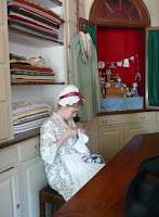
Going to Colonial Williamsburg is like suddenly walking into the 18th-century capital of Virginia.  There are homes, public buildings, museums and stores, preserved and restored to the way they were just before the American Revolution.  People wander around in colonial costume, and there are historic demonstrations and interactive programs all over the place. 
At the Visitors Center, we saw the movie, then followed the path out to the Governor's Palace.  We got there in time for a tour, then headed up Palace Green for a couple of blocks until we got to Duke of Gloucester Street.  The Capitol Building is at the far end so we headed that way.  
George outside Governor's Palace gate
We stopped along the way at several of the little shops where they were actually doing the work like it was done back then.


My favorite was Charlton's Coffeehouse, where we not only got a tour, but "Mrs. Charlton" served us coffee, tea or hot chocolate.  We both opted for hot chocolate, which is not at all like the sweet stuff served in this century!  Yum...   
 
 We toured the Capitol & the Gaol House (that's "jail" in American English), visited the weaver and the shoemaker, learned lots of stuff about the events leading up to the revolution and how people felt about both the British and the war.
Things pretty well shut down at 5:00, so we hiked back to the truck.  George had had his fill, but I hadn't so I went back Wednesday while George went to play golf.  I got to see the "Revolutionary City" dramatizations that we got there too late to see on Monday.  All over town actors dressed up like merchants and townspeople talking about the events that were affecting them.


We started out in front of Raleigh Tavern, then followed the actors up to the Capitol, over behind the coffeehouse and then back to the tavern.  The program that day was about the Challenge of Independence, and was about events between 1776-1781.  There was one skit about recruiting soldiers for the militia; one with Benedict Arnold after he'd gone over to the British; one about how the revolution was affecting slaves; another with General Washington just before the Battle of Yorktown.
Pretty painless way to learn history!  More pictures of Colonial Williamsburg