July 31, 2015

7/26/15 - Little Bighorn Battlefield NM

Little Bighorn Battlefield National Monument is in Montana, not Wyoming like I thought. We met up with friends at a nearby RV park and went together to the battlefield commonly known as "Custer's Last Stand". The monument is just off I-90 so it's handy for people traveling between actual points of civilization on their summer vacations to stop off to see the battlefield. (It wasn't designed that way; the battlefield was first; the freeway came later.)

We found a couple of parking places near the cemetery so we decided to check that out first. (It was okay...we already knew who won the battle.)  Custer isn't buried here; he's at West Point.

The Visitor Center was impossible.  It's outdated and way too small for the number of people trying to fit into it. You could barely squeeze your way through the poorly-lit museum to the auditorium where they were showing the movie. There wasn't even room left inside for standing room.  I like the painted buffalo hide which is an Indian representation of what the Lakota call the "Battle of Greasy Grass Creek". The rest of the display is pretty hokey though. (I really would have liked to have seen the movie--but that's okay, we already knew who won.)
We didn't want to wait another hour for the next movie, so we went outside to the patio for a Battle Talk by one of the rangers. This battle has been written about more than any other battle in US history. I think the ranger had read most of them.  People have very definite opinions on General George Armstrong Custer, even before they get here.  (Mine might have been changed a tiny little bit from what I learned about him at Civil War battlefields and Washita Battlefield in Oklahoma, but I'll never join the Friends of the Little Bighorn.) We had a great view of Last Stand Hill and the Trail to Deep Ravine (below).
After getting a crash course on the battle, we got in the truck to follow our friends Larry and Carolyn on the 4-1/2 mile tour road. (Yes, I know it looks just like a road through rolling prairie. That's pretty much what the whole place looks like.  Did you expect something different?)  There are 17 tour stops--four heading out to the Reno-Benteen Battlefield, and the rest on the way back. We, of course, stopped at all of them.
There are information signs explaining what happened in this gully or on that ridge, but I still wish we'd seen the movie... (No, never mind!  I already know who won.)  
Okay, I'm not going to explain anything about the battle here.  All I know is from the info signs (because I didn't get to see the movie and I haven't read the books.)  I did post pictures from each of the stops on Flickr, so you can check them out if you want.  If you want to know more, there are hundreds of books, even more websites--or you can come visit the battlefield yourself.  But I'll share some things that impressed me.

Custer had 600 soldiers and 263 of them died here. There were 7,000 Lakota, Cheyenne and Arapaho in an encampment on the Little Bighorn River.  1,500-2,000 of them were warriors and about 30 died. (I think Custer may have been mathematically challenged and would have bought lots of lottery tickets if he lived now. Obviously Sitting Bull had no problem with basic arithmetic.)

They've put up markers wherever they found a body--some are soldiers and some are Indians.  The Indians took their dead away, so it's more difficult to identify the actual locations. Red granite identifies Cheyenne and Lakota Warrior Markers, in contrast to the white marble headstones used for the Army. There were Indian scouts from other tribes who fought with Custer; there was even a civilian war correspondent and they have white markers too.
 
Even the horses that died have a marker.
At the turnaround, I thought we might get to see another kind of battle.  Because it's so close to I-90, a lot of people just drive in with their big motorhomes. There's not a lot of parking, and if several of them are already parked, it's hard for others to get past. Looked like it was going to be The Battle of the Giants, but they got it sorted out. They would have had to make HUGE markers after that!
The appropriately named "Last Stand Hill" is where Custer made his...ummm...last stand. The US Army Memorial is a big obelisk with everyone's name, and there's an enclosure with markers to show where the soldiers fell. The one with a black background near the center is Custer's. His brother's is directly in front of his. I didn't know his brother served with him.
 
Across the road is the Indian Memorial. The best view is from the hill, but I forgot to take a picture of it from there.  You can see most of it behind George in the picture (above). You enter the Memorial Circle through a Spirit Window. The inside walls are a memorial to the five tribes who fought here. The Spirit Window Sculpture represents the warriors who fought in the battle. Lots of symbolism.
 
Although I didn't get to see the movie--I know who won the battle...and I know who won the war. 

More pictures here:  Little Bighorn Battlefield Natl Monument

July 24, 2015

7/20/15 - Rocky Mountain NP

When I was a kid my cousin and aunt took me on a trip that went through Rocky Mountain National Park in Colorado. It was July and there was still snow by the road so I thought that was pretty cool. This year George and I finally made it there--no snow by the road but it was still cool. We were staying at a campground near Fort Collins so we drove in through Estes Park and then headed up US 34 to the Fall River Visitor Center.

Just before we got there, traffic was stopped! Some bighorn sheep were crossing the road and, of course, everyone had to gawk.  George drove very sloooowly and I took pictures out the side window. Motley-est bunch of critters I've ever seen!  July is apparently when Bighorn Sheep shed their fleece naturally, but it's not a pretty sight.
This guy seems to have it down though...umm, no pun intended.
When we finally got to the Visitor Center, the student intern told us to just drive up the Trail Ridge Road. Then I started talking to a super-nice (older) volunteer who suggested a better route--he said the Old Fall River Road was recently reopened after being closed all last year because of the 2013 flood damage and it was definitely worth the trip. He wrote all over my map and told us where to stop for the best views and hikes. (You should always make a point to talk to old people--they're very knowledgeable and often enthusiastic.  Enthusiasm is very underrated.

Just past Sheep Lakes we turned off the main road. (There were sheep in the meadow but they were a long distance away.  They're motley anyway so you're not missing anything.)
In 1982, the Lawn Lake Dam broke and left an alluvial fan of flood debris.  All these big boulders and rocks were left by the flood. Now it's a nice place to hike. And there are pretty wildflowers too.
This stuff is called sulphurflower, because it's yellow, I suppose.
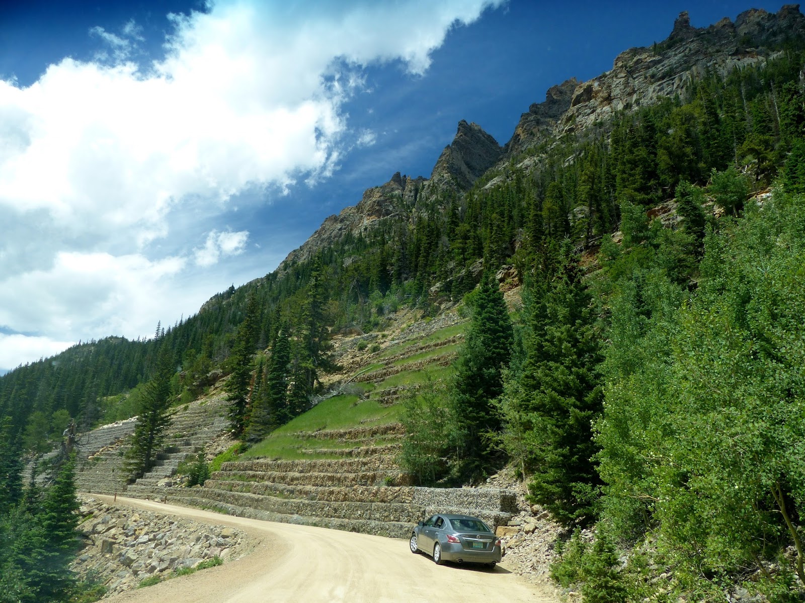
After two miles of pavement, the road becomes a gravel road. This was the first road in the park that took visitors up into the high country. It's one-way uphill, with lots of switchbacks and no guard rails.
It's only 9 miles on to Fall River Pass (11,796' high) but at 15 mph and lots of stops for pictures it seems farther.
We saw a couple of waterfalls alongside the road before we got to Chasm Falls, where we had to walk a bit to see it.
At one place there's a big retaining wall made of blocks of chicken wire filled with rocks. Makes you wonder what happened here...I'll bet somebody got clobbered. 
One of the best parts of this road is that you're a lot closer to the high peaks of the Mummy Range so you look straight up to see them instead of across the valley.  I really like craggy mountains! That's the way mountains are supposed to look.
There are wildflowers everywhere. The red one's Indian Paintbrush; the white one is Western Bistort. I don't know about the yellow ones...


There's still snow remaining in the mountain shadow, but it's melting. There are trickles of water--even if you can't see them, you can still hear them. Wonder if this part of Colorado is in the drought area?
You can see where the snow blew over the ridge last winter. This section of the road just before the Alpine Visitor Center gives "off the side of the road" a whole new meaning.
Alpine Visitor Center is at the top of the pass. Lots of people were hiking across the tundra and up the Ridge Trail--elevation gain of 300' in 1/4 mile to above 12,000'.  But it was windy and it was cold, so we went into the gift shop instead. (I didn't buy the "I made it to the top" t-shirt--that would be tacky.) But even the view from the parking lot isn't bad.
Turning left out of the parking lot put us on Trail Ridge Road, which IS paved...and wider. Lots more traffic than the Old Fall River Road. Rocky Mountain NP has the highest paved roads in the national park system--and this one is the highest continuous paved highway in the U.S. We stopped at Lava Cliffs for the view (or was that because there was a pullout?)
Actually, we kept stopping at the pullouts...for the view.  There's a little alpine lake in this picture. If the sky were bluer, the lake would be too. (If you can't see it very well, just double click on the picture and it will open another tab and enlarge it.)  Sorry, I can't control the weather but I do think these big black clouds are dramatic. George doesn't have the same opinion...but he's the worrier in the family.
At one of the stops we saw yellow-bellied marmots. And cute little pikas at another.
    
Then on a slope by the side of the road we saw a whole herd of elk! (I get excited about seeing all these animals because so often we don't...even when other people do, we don't. I do, however, have a good imagination and frequently see animals that aren't really there. Ask George.) Some of the elk were growing antlers, some had calves, a couple even had radio collars.

Sky sure was getting dark. When it started raining, George wasn't as willing to stop for pictures. Let's see...mountains, rainstorm, lightning...maybe he's right.
But it didn't last long, so we got one more picture of the two of us.
I really like this park a lot. Next time we'll come in from the southwest and do the other half of the Trail Ridge Road. My cousin Charlotte and I remember that the mountains were more dramatic coming from that direction.  They'll have to go a lot to surpass what we saw this time around.

More pictures here:  Rocky Mountain Natl Park

July 23, 2015

7/21/15 - Cache la Poudre Scenic Byway

My cousin Terry and his wife live just outside Fort Collins, CO.  One day while we were there, he took us for a drive up the Cache la Poudre Scenic Byway. (Actually, I didn't know that's where we were going because they kept saying "the Pooder".  I guess it's a Colorado thing...)

Terry drove. Good thing I didn't have to navigate for George because my sense of direction around this part of the country was pretty messed up. It's often at least 90 degrees off, but sometimes it's more like 180. Consequently I have really no idea where we went. I think we went sort of west (which was probably north), then south (possibly west); it was a twisty road going through a canyon with a river in it...and a really cool tunnel.
The Cache la Poudre is a Wild and Scenic River.  That's not just my description--that's a federal designation. Since 1962, 203 segments of rivers in 39 states have been protected from dams and development. Sounds like a lot but it's less than 1/4 of 1% of the rivers in the US.  Who knew???
Sometimes the river is nice and calm. 
And sometimes there are some pretty wicked rapids.
Sometimes when there's white water, there are rafters. Terry drives a bus for one of the rafting companies. Couldn't talk George into it. Maybe sometime... (Insert "when pigs fly" or "when hell freezes over".  Either would work for George.) These guys had just put in and were getting organized.
We didn't drive the full 105 miles of the scenic byway, but enough to appreciate how pretty the canyon and river are. There were wildflowers...


More pictures here:  Cache la Poudre River Natl Heritage Area