August 31, 2013

8/20/13 - Harpers Ferry NHP

You'll probably be glad to hear that I've had enough battlefields for awhile, so this won't be a battlefield post. There will definitely be history--and that's the point of Harpers Ferry National Historical Park.  (Actually there were battles there during the Civil War, but there's plenty of other stuff to do around town.)

We took the shuttle bus from the Visitors Center--really more of a kiosk--to Lower Town (which is in the park), then to the Info Center at the Master Armorer's House to get an idea of what's there and where to go.  Kind of a weird setup, but it works.
  
Lots of history in Harpers Ferry.  Seems like everyone stopped there at one time or another:  George Washington, Thomas Jefferson, Meriwether Lewis, Abraham Lincoln, John Brown.  There are bridges all over the place near "The Point" where the Shenandoah flows into the Potomac:  a couple RR bridges (one's for the B&O RR from my Monopoly game) with this pedestrian bridge alongside one of them.
   
    
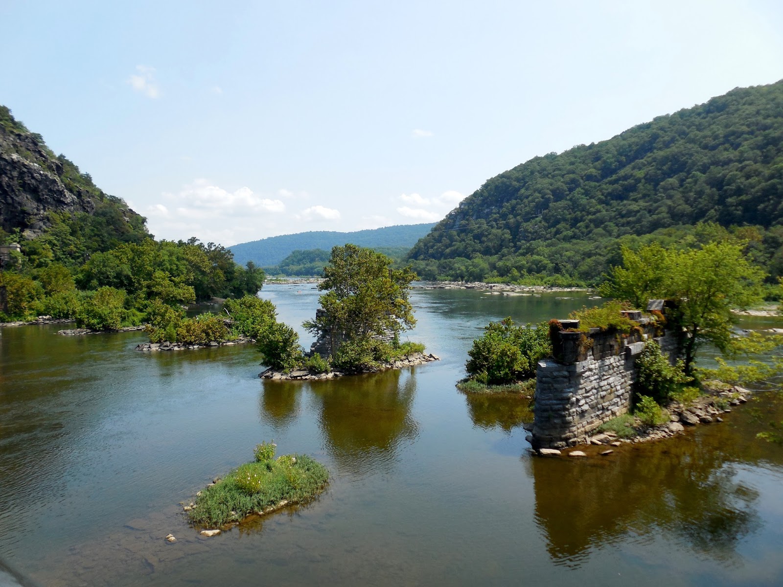
Here's the remains of an old wooden bridge destroyed 9 times by armies and floods during the Civil War, and more pilings of another one.  I do like bridges.
 
The Park Service realize people have different interests, so they set up 6 different themes to follow around the park. Most of the old buildings are now mini-museums.  
Industry:  The town became an industrial center when the US Armory and Arsenal was built there.  Like the one in Springfield, MA, they made and stored guns for the military.  It was blown up by the Federals during the Civil War, so the Confederates wouldn't get the guns.  But the equipment to make them was saved, and they got moved south.  This is where part of the Armory stood. 
Meriweather Lewis stocked up on rifles and ammunition at the Armory before he and William Clark left on their NW journey.  He has his own museum.
 
Natural Heritage:  The Shenandoah flows into the Potomac at Harpers Ferry and then through the water gap, past the kayakers and the highway bridge a mile away.
  
Transportation:  Railroads, canal, ferries--the trains still come through the tunnel.  The C&O Canal towpath is now part of the Appalachian Trail, where hikers and bikes share the road.  You can see bits of all of it here.
John Brown:   The radical abolitionist's raid to seize 100,000 guns at the arsenal was a plan to free slaves.  The Armory fire station where he holed up has been renamed as "John Brown's Fort".  (This was one of the themes I was interested in.)  Brown's raid failed and he was captured and hanged, but it sure was a catalyst for the Civil War.  Here's something cool:  Union soldiers came up with a catchy marching song called "John Brown's Body" (which I remember from grade school).  Later when Julia Ward Howe wrote "The Battle Hymn of the Republic", she put her words to that tune.
   
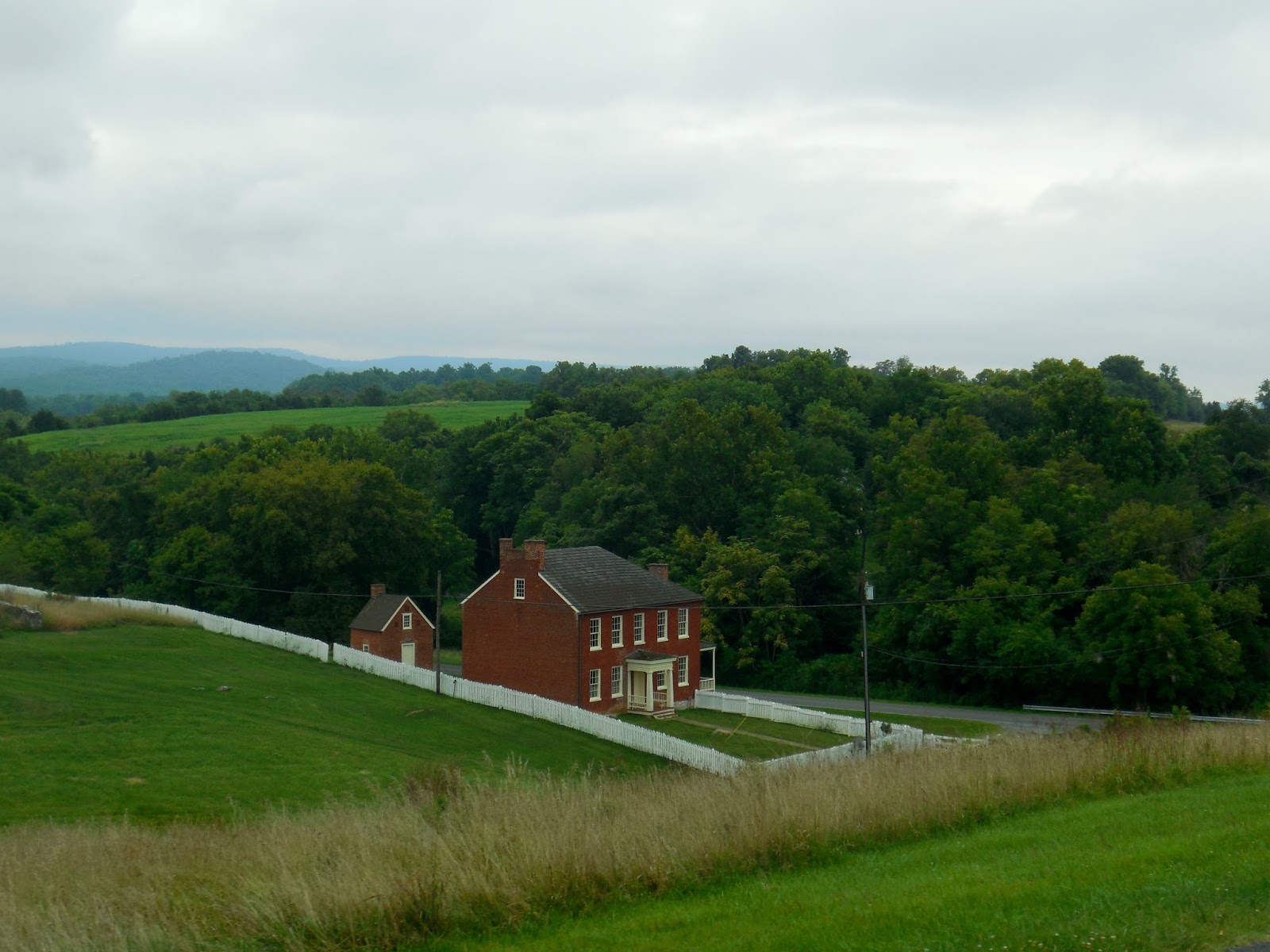
Civil War:  The Civil War was terrible for Harpers Ferry.  The town changed hands eight times during the war. Two days before the Battle of Antietam, Gen. Robert E. Lee sent Stonewall Jackson to capture the town to protect his supply route.  Over 12,000 Federal troops surrendered.  This is what Bolivar Heights Battlefield looks like now.  I took a total of SIX pictures here.    


African American History:  History here mirrors that of the country--from slavery to a place of refuge for runaway slaves to one of the first schools for black students and then on to the Niagara Movement.  The old Storer College is now an NPS Training Center. 

And I'll add one more theme, Appalachian Trail:  The trail is only in West Virginia for 4 miles, and it runs right through town.  Hikers come down the old Chesapeake & Ohio Canal towpath on the Maryland side of the Potomac, then cross the river on an old railroad bridge to the "psychological halfway point".
  
Hikers go down these steps off High Street (or up, depending on whether they're heading northbound or southbound).
The Appalachian Trail Conservancy is headquartered up on the hill.  Hikers can stop in to use computers in the Hiker's Lounge, or get all the information imaginable about the AT from the friendliest volunteers ever!
I'm pretty sure we'll never walk the whole trail, but it's kind of cool running across it all over the place.

Click the link for more pictures of Harpers Ferry NHP

August 30, 2013

8/19/13 - Antietam NB

It was a dark and gloomy morning...but we only had three days in the area and I had them all planned out. Today was the day to visit Antietam National Battlefield near Sharpsburg, Maryland.  If we got rained on, we got rained on.  Besides, we're from Seattle, aren't we????

History Alert:  Though they were on the same battlefield, the Union Army called it the Battle of Antietam (a nearby creek), it was referred to as the Battle of Sharpsburg by the Confederates.  I imagine this can be confusing on history tests, but you won't have to worry about that.  

This battle was an accident.  Lee was on the offensive into northern territory, but had to split his army into four sections.  A copy of his orders to one of his generals was lost--then found by a Union soldier--wrapped around 3 cigars.  After smoking the cigars, the word got passed to the officers.  When Gen. McClellan read them, he knew he had the Confederate battle plan in his hand and he could strike while the Rebels were divided.

I don't know if I've mentioned this before, but there are markers like these at all the battlefields.  They explain in detail what actually happened at a particular site.  Sometimes give a , and a complete description of who did what, when, where and why.  Plus NPS puts up informational signs all over the place too.
 
The battle only lasted 12 hours that day in September of 1862, but Antietam/Sharpsburg (pick your preference; pick your side) became the bloodiest one-day battle of the Civil War.  I always see the casualty numbers posted all over and think they're obscene and disheartening for both sides.
 
The Dunker Church looked just like this, but it was in the worst part of the worst battle of the Civil War and was shot all to pieces.  Ignored by locals and scavenged by tourists, it collapsed during a storm in 1921.  For the 100th anniversary of the battle, it was rebuilt by NPS in 1962.  It looks just like it did when it was an active congregation.  I don't know why they didn't add the holes from the cannon shot and bullet scars.  After all, authentic is authentic.
Alexander Garden took photographs several days after the battle.  This one of Dunker Church is one of the most famous of the war.  When they were exhibited at Matthew Brady's (I've heard of him!  He took pictures of Lincoln.) gallery in NYC, they shocked the public because they didn't match the romantic paintings they'd seen of battles.  It made people think a different way about the war.  We get the same thing now from war correspondents in the Middle East.  
We wandered around the Poffenberger farm near the North Woods where General Hooker's men spent the night before the battle.  Apparently they did a lot of damage to many of the farms around here with little recompense from the government.  (Surprise, surprise.) Ordinary people were pretty ticked off.
Lots of places here look innocuous now.  These cornfields and fields, woods and farms were all scenes of terrible fighting.  They're trying to make the battlefield look a lot like it did then.  They're planting trees where woods that played a critical part stood.  They've leased out the fields to be farmed (although I'm pretty sure soybeans weren't planted in Maryland in 1862.)  Then you see a sign like the one below that shows details of the engagement.  (And, yes, it's a fly on the sign.  I can't go back and shoo it away now.)


This farm road served as a breastworks (temporary fortification) for the Confederates.  It was a good position for awhile but then they were stuck and couldn't get away in any direction.  Afterward the dead lay in rows.  Photos at the Visitor Center are pretty graphic. 
At Lower Bridge across Antietam Creek, five hundred Confederates held off Federal troops for over three hours.  Bodies were piled on top of each other.  Picturesque isn't picturesque in war.  They've renamed the bridge Burnside Bridge.  (Monuments and bridges are named after the victors.)
Basically a draw, when the Armies left the area, the dead and wounded were left behind for civilians to care for.  Think that didn't mess up people's lives? At first they buried the bodies where they fell.  Later Union soldiers were reburied here at Antietam National Cemetery.  The Confederates were buried in other towns.


Things that came out of this battle that changed the world:
  • Emancipation Proclamation 
  • Clara Barton (A symbol of the Red Cross was made from a brick from the home where she was born and placed at the base of the monument--isn't that cool?)
  • Ambulance corps
  • Triage
I always think I won't do much on blog entries for battlefields, then I put down all the stuff I learned.  Maybe I'm still thinking I'll get extra credit or something?  I've got more pictures of Antietam here:  Antietam Natl Battlefield

8/22/13 - Flight 93 National Memorial


We actually hadn't planned to go to the Flight 93 National Memorial because we'd heard it wasn't finished yet. But as we were checking in at an RV park in southwestern Pennsylvania, we learned we were only about 25 miles from the site.  The park manager said it was definitely worth a trip.  I asked her about what it was like on that day. Personal stories are always the best.


There's a 3 1/2 mile drive to the Memorial Plaza from the entrance, winding through old surface coal mining land. Forty groves of forty trees have been planted along the entry road, one grove for each one of the forty victims.  They're just saplings now but will be even more impressive in a few years.
Panels near the Visitors Shelter tell the story of September 11, 2011, when the actions of the passengers and crew of United Airlines Flight 93 prevented the plane from attacking the White House or Capitol Building in Washington, DC.  They don't really know the details of what they did, but they're definitely heroes.
It's a quarter of a mile down this walkway to the Wall of Names.  The Black Wall marks the edge of the debris field of the crash site.  The big bench on the right is intended for contemplation. There are niches in the walls where people leave tributes to the victims.
The plane flew across this field, crashing just in front of the trees in the distance.  After the FBI investigated the site, the coroner directed the crater to be filled.  The field and woods are the final resting place of the passengers and crew of Flight 93.  They call it the Field of Honor.
The Wall of Names is very simple and elegant, one name inscribed on each of the forty accordion-fold marble panels.
Just before the Black Wall meets the Wall of Names is a small wall, and behind that is a ceremonial gate.  Looking through the spaces between the wooden boards along a path mowed through wildflowers, you can see a boulder marking the general location of the impact site.
The yellow flowers are black-eyed susans, and they are all over the place!  I haven't figured out whether they seem out of place, or if they're just perfect.  I know I like them.
We got back to the Visitor Shelter in time for a ranger-talk.  He talked about the day, the investigation, the plans for the memorial.  I didn't realize until later that he didn't talk about the terrorists, but that's just fine.  The memorial isn't for them anyway.  
A lot of thought and symbolism went into this memorial.  The architects plan is for it to be a place of renewal.  The land around here was used for surface mining of coal, and the reclaimed land is mostly grassland.  They plan to build a big Visitor Center complex, divided .  Near the entrance will be the Tower of Voices, with forty wind chimes.

So even though the memorial isn't finished, it's worth a trip.  (Take a hankie.)  As far as I'm concerned, if they never built any more, it would be enough.  It's simple, almost stark, but a lot of thought was put into this tribute to the passengers of Flight 93.

A few more pictures here:  Flight 93 NM 

August 29, 2013

8/17/13 - Chesapeake & Ohio Canal NHP


On the way back from Catoctin Mountain Park, we detoured to Williamsport, MD to visit the old C&O Canal towpath which stretches 184.5 miles along the Potomac River from Washington, DC, to Cumberland, MD.   The canal closed in 1924 and sat abandoned for years.  Now this recreational piece of history is Chesapeake and Ohio Canal National Historical Park.   


The Cushwa Basin Visitor Center is one of 7 visitor centers along the towpath.  It's located in the old Cushwa Warehouse, itself a piece of history.  George got his passport stamps, then we watched the videos:  the current NPS one and a funky silent one with subtitles filmed in 1917, called "Down the Potomac".  Originally a dream of George Washington, the C&O Canal was dedicated by President John Quincy Adams in 1828, and was used for almost 100 years.
On weekends, rangers take visitors on boat rides on the 3/4 mile section of the canal up to Lock 44.  We got there too late to get one of the free tickets, but the ranger told us we could meet the boat at the lock for his talk.
The Trolley Barn Power Station is across the parking lot.  We walked past it on the way down to the towpath.  We didn't know what it was until later and didn't go back to check it out.  George says it's too late now.
Although all you see on the towpath now are people walking or biking, a towpath was the 12' wide road alongside a canal where mules trudged to pull barges past difficult sections of a river.  Squint your eyes a little and you might see mules plodding along the path, hauling barges upriver.  Whether you have to avoid their droppings is entirely up to your imagination!  Depends on how your day's been going, I suppose.

North on the towpath, is the Conococheague Aqueduct, a water bridge used to carry canal boats over creeks and rivers that flow into the Potomac.  Conococheague Creek meets the Potomac here. Please don't ask--I have absolutely no idea how to say it. Apparently the folks around there haven't agreed on one pronunciation, so I got a couple of different answers.
We turned the other direction, went under US-11 and past this old Railroad Lift Bridge from 1923.  It lifted the railroad tracks for the canal boats to go underneath.  There was a big flood a year after it was built so they didn't have to use it very long.
      
Next along the towpath is the Bollman Bridge.  It was built in 1879 by one of the first guys who engineered iron bridges.  It's the only bridge over the canal. 
Here we're almost to Lock 44.  Since we got there first, we had time to wander around.
The lockkeeper at Lock 44 was on call 24/7, although I'm pretty sure that's not 19th century terminology.  He got a salary, a rent-free house and an acre of land.  The ranger took us inside the Lockhouse, just across the towpath from the Lock, where the lockkeeper and his family lived. It looks like they've done a lot of work on the outside, and are starting to get it fixed up inside. The park and the canal trust have made six of the other lockhouses available for overnight stays.  Wouldn't that be cool if they did that to this one too? 
 
Back outside, the ranger explained how the locks lower and raise the boats to another level--like stairsteps with water.  I've been through the Ballard Locks in Seattle from Lake Washington to Puget Sound and we took a ride on the Erie Canal in NY, so I've seen locks at water level.  Although there's no water flowing, the demonstration showed us how some of the old locks worked from the lockkeeper's point of view.  Pretty cool.  
Lock 44 with gates open


First the ranger had us close the gates.
He used this wrench...
...to open and close doors at the bottom
 to let the water in and out of the lock.
On the way back, we stopped to talk to a couple who were fishing.  (It's catch and release; no one would want to eat anything that came out of that nasty water!) Turns out he'd retired from the Secret Service, so he and George hit it off immediately and talked "cop". The boat passed us while we were chatting.

I think this towpath and park is better than the Ohio & Erie Canal towpath in Cuyahoga Valley National Park near Cleveland (see May, 2013, entry for our visit there.)  And I think it's designated correctly as a National Historical Park.  (End of rant.  Go check them both out yourself, and then let me know what you think.)

Here's the rest of my pictures of Chesapeake & Ohio Canal NHP